


Results 1 to 10 of 10
-
6th October 2019, 06:57 AM #1


 City Navigator East and West Africa NTU 2019.20
City Navigator East & West Africa NTU 2019.20
FID 7936
CP 65001
Until Garmin releases this map officially and comes up with a better coverage, here's the combined East & West Africa coverage map:

BaseCamp view.
East Africa
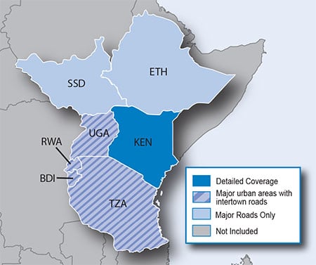
Coverage
• Burundi
• Kenya
• Rwanda
• Tanzania
• Uganda
• South Sudan
Burundi
• Metropolitan area coverage for the cities Bujumbura, Makamba, Gitega, Nyanza, Kirundo, Muyinga and Ngozi.
Ethiopia
Kenya
• Detailed coverage for the cities of Athi River, Kiambu, Kiserian, Kitengela, Mlolongo, Ngong, Ongata Rongai, Ruiru, Thika and Turitu. Metropolitan area coverage for the cities of Mombasa, Eldoret, Nyeri, Malindi, Ukunda, Nakuru, Kisumu and Watamu.
• Road coverage for Nairobi National Park.
Rwanda
• Metropolitan area coverage for the cities Kigali and Huye.
South Sudan
• Metropolitan area coverage for North Bahr Al Ghazal, West Bahr Al Ghazal, and the Upper Nile.
Tanzania
• Major metropolitan area coverage includes Dar es Salaam, Zanzibar, Mbeya, Musoma, Shinyanga, Arusha, Moshi, Morogoro, Mwanza, Tanga, Dodoma, Iringa and Songea.
• Road coverage for the following parks: Mkhomazi Game Reserve, Katavi National Park, Selous Game Reserve, Mikumi National Park, Serengeti National Park, Tarangire National Park, Lake Manyara National Park, Ruaha National Park and Ngorongoro Conservation Area.
Uganda
• Major metropolitan area coverage includes Kampala, Gulu, Lira, Mukono, Jinja, Mbarara, Mbale, Masaka, Iganga, Tororo, Busia, Soroti, Wakiso, Entebbe, Njeru and Mpigi.
• Road coverage for the following parks: Aswa-Lolim Game Reserve, Bokora Game Reserve, Kidepo Valley National Park, Matheniko Game Reserve, Mt. Elgon National Park, Murchison Falls National Park, Pian-Upe Game Reserve and Queen Elizabeth National Park.
West Africa
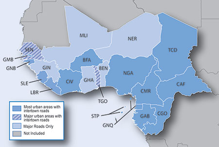
Coverage
• Nigeria
• Liberia
• Guinea-Bissau
• Sierra Leone
• Benin
• Togo
• Ghana
• Ivory Coast
• Guinea
• Gambia
• Senegal
• Burkina Faso
• Mali
• Niger
• Cameroon
• Central African Republic
• Chad
• Equatorial Guinea
• Gabon
• Republic of Congo
• Sao Tome and Principe
Details
DOWNLOAD
Original Images Locked.
Additional files.
Use the latest WinRAR to unpack.
.IMG unlock (separate) with gimgunlock-0.04.exe
Genius3 Reviewed by Genius3 on . City Navigator East and West Africa NTU 2019.20 City Navigator East & West Africa NTU 2019.20 FID 7936 CP 65001 Until Garmin releases this map officially and comes up with a better coverage, here's the combined East & West Africa coverage map: https://i.imgur.com/Z0z4IeD.png BaseCamp view. https://i.postimg.cc/D0f3q9J5/BC-East-West-Africa.png (https://postimages.org/) Rating: 5Last edited by Genius3; 27th October 2019 at 01:33 AM. Reason: Renewed one link.
-
The Following 4 Users Say Thank You to Genius3 For This Useful Post:
- [ Click To Expand ]
-
ance (1st March 2020), sspeeder (7th November 2020), StrikeForce (6th October 2019), zhangxin0926 (29th July 2020)
-
6th October 2019, 02:43 PM #2
For information:
The img files for the old 2017.20 version have following size:
- East Africa: 711 MB
- West Africa: 1.31 GB
The img file for this new (combined) 2019.20 version has following size:
- East & West Africa: 214 MB
-
6th October 2019, 05:07 PM #3
Can we have it on zippyshare ? Just the map.
This server is keep breaking my downloading.Last edited by Sebo_; 6th October 2019 at 05:54 PM.
-
6th October 2019, 07:11 PM #4
In addition to the (much) smaller .img files the 2017.20 ones are NT (rather than NTU) and thus will work on older units.
I doubt NTU maps are that much smaller than NT.
Interesting...
. o O (Perhaps Garmin is moving to the NTU format for all maps)
-
7th October 2019, 05:35 AM #5
Can we have it on zippyshare ? Just the map.
This server is keep breaking my downloading.
-
7th October 2019, 03:27 PM #6
It's my guess that this 2019.20 NTU version is way less detailed, compared to the 2017.20 NT version.
This assumption is based on the statement in post #1: "Until Garmin releases this map officially and comes up with a better coverage".
-
7th October 2019, 08:24 PM #7
Maybe. Whatever the case my units don't support NTU maps so I'm sticking with the 2017.20 NT .img files and the 2016.10 gmap (PC/Mac) versions.
-
8th October 2019, 09:00 AM #8

I would advise caution with ANY maps that deal with the less recorded world south (South America, some parts of the Middle East, Africa in its totality and Southeast Asia) and proceed with your professional risk and judgement. My family recently went to Costa Rica with the LATEST maps last August. There were many occurrences where we found ourselves in an area where the GPS coverage was having a hard time keeping us on the road but we were simply following the route in front of us. Some roads listed on the Nav weren't even roads at all! In the pictures below we were en route to Tenorio National Park/Celeste Mountain Lodge from Arenal National Park and you can clearly see how off it was:
The funny thing is that when we arrived, they said there was a longer, but paved road to the lodge instead of the dirt/rocky ATV road that we got stuck on for over 2 hours.
-
The Following 1 Users Say Thank You to DXOS3 For This Useful Post:
- [ Click To Expand ]
-
StrikeForce (9th October 2019)
-
8th October 2019, 10:19 AM #9
Garmin Mod
Supporter

These maps are only the reduced Road maps from the Garmin Overlander All-Terran device and are paired with TOPO maps to give a balance between On & Off Road.
The EU version of the Overlander is Preloaded with iOverlander™ points of interest (POIs), ACSI™, Campercontact™ and Trailer's PARK a total of 1.58 GB of POI
-
The Following 1 Users Say Thank You to Garmin_Nuvi For This Useful Post:
- [ Click To Expand ]
-
StrikeForce (9th October 2019)
-
4th December 2019, 05:34 PM #10
Last edited by Garmin_Nuvi; 5th December 2019 at 11:50 AM.


 Register To Reply
Advertisements


Suggested Articles:


 Staff Online
City Navigator Europe NT 2025.10...
I would get a 32GB SD card they are only a few...