


Results 191 to 200 of 254
-
10th August 2020, 03:24 AM #191

-
1st September 2020, 09:36 PM #192
 Garmin Topo Active PowerSports Europe 2020.10
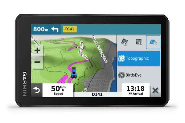
The zumo XT comes preloaded with TopoActive PowerSports maps for Europe, which are a little different than traditional Outdoor TopoActive Maps.
The Powersports color scheme emphasizes unpaved/dirt roads for offroad activities and is tailored to match the look and feel of the City Navigator maps
Feature colors are also optimized for use with the automotive map engine and zumo XT display
Since Powersports is tailored for the Automotive displays, it would not look good on Outdoor/Fitness devices
Coverage for the Powersports maps is exactly the same as standard TopoActive
Features included in TopoActive Maps:
TopoActive maps are not used for routing
International boundaries, waterways, natural features, land use areas, historical sites, airport structures, buildings, boundaries for national parks, national forests and more.
Contour or elevation lines are at roughly 100ft intervals
Contour line information varies based on location and detail the OpenStreetMap has for that area
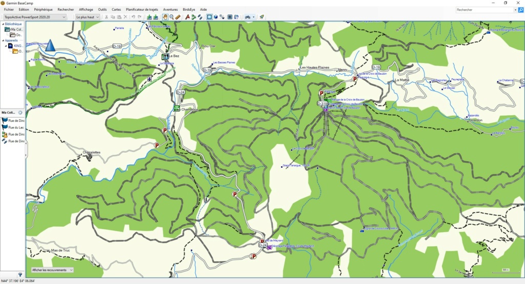
Trail Coverage
Any trail, dirt road or road added to OpenStreetMap is added to the Garmin map
We do not limit which trails or roads we include
One advantage is the ability to interact with the map by adding trails or other relevant content which we can include in the next update
See the OpenStreetMap website for more info
Garmin Express is used for TopoActive map updates
These are updated periodically throughout the year, usually in the Spring and Fall
Includes topographic coverage of 47 countries in Europe: Albania, Germany, Andorra, Austria, Belarus, Belgium, Bosnia and Herzegovina, Bulgaria, Croatia, Cyprus, Denmark,
Spain, Estonia, Finland, France, Greece, Hungary, Ireland, Iceland, Italy, Kosovo, Latvia, Liechtenstein, Lithuania, Luxembourg, Macedonia, Malta, Moldova, Monaco,
Montenegro, Norway, Netherlands, Poland, Portugal, Czech Republic, Romania, United Kingdom, Russia (Kaliningrad only), San Marino , Serbia, Slovakia, Slovenia, Sweden,
Switzerland, Turkey, Ukraine and Vatican.
The quality of the coverage will depend on the region. Urban areas will typically be more developed while coverage in rural areas may not be very good. TopoActive Maps are a Garmin OpenStreetMap Product.
Download Link:
Download Link:
Note:
This is the original img file from a ZumoXT Gps.
Last edited by P i l o u; 22nd December 2020 at 02:23 PM.
-
The Following 7 Users Say Thank You to P i l o u For This Useful Post:
- [ Click To Expand ]
-
bommelb (13th September 2020), FireFox58 (1st September 2020), Garmin_Nuvi (12th September 2020), raioxis (2nd September 2020), willi59 (3rd September 2020), willimeier@byom (16th October 2020), wolkowitz (5th December 2020)
-
12th September 2020, 10:36 PM #193

Hi y'all
Is there any chance you could help me find TopoActive MENA?
But it does say it's"community generated open street map data", would that mean I could get this same map if I generated from the osm website?
Moderator Note
Welcome to the forum,you are obviously correct,let see if we can find them for youLast edited by Garmin_Nuvi; 13th September 2020 at 01:49 PM. Reason: Made separate post on thread
-
28th November 2020, 06:15 AM #194


Garmin TopoActive Europe 2020.20
FID 8829
CP 65001
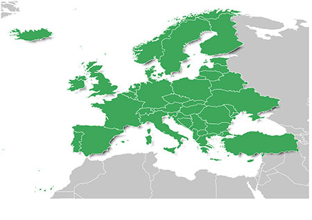
Features topographic coverage for 47 countries in Europe: Albania, Andorra, Austria, Belarus, Belgium, Bosnia-Herzegovina, Bulgaria, Croatia, Cyprus, Czech Republic, Denmark, Estonia, Finland, France, Germany, Greece, Hungary, Iceland, Ireland, Italy, Kosovo, Latvia, Liechtenstein, Lithuania, Luxembourg, Macedonia, Malta, Moldova, Monaco, Montenegro, Netherlands, Norway, Poland, Portugal, Romania, Russia (Kaliningrad only), San Marino, Serbia, Slovakia, Slovenia, Spain, Sweden, Switzerland, Turkey, Ukraine, United Kingdom and the Vatican City.
Garmin | TopoActive Europe
DOWNLOAD
13 RAR archives, unpacked size 7,42 GB
inside
Details
NOTE:
.RAR files unpack with WinRar v5.61 or later.
All .IMG files are genuine and untouched.
4 Maps gmapprom.img, D6185090A.img, gmapdem.img & gmapbmap.img are not Locked but are Signed
Unlock Maps with Tool: gimgunlock-0.04
-
The Following 7 Users Say Thank You to Genius3 For This Useful Post:
- [ Click To Expand ]
-
-
21st December 2020, 03:53 PM #195
Garmin Topo Active PowerSports Europe 2020.20
The zumo XT comes preloaded with TopoActive PowerSports maps for Europe, which are a little different than traditional Outdoor TopoActive Maps.
The Powersports color scheme emphasizes unpaved/dirt roads for offroad activities and is tailored to match the look and feel of the City Navigator maps
Feature colors are also optimized for use with the automotive map engine and zumo XT display
Since Powersports is tailored for the Automotive displays, it would not look good on Outdoor/Fitness devices
Coverage for the Powersports maps is exactly the same as standard TopoActive
Features included in TopoActive Maps:
TopoActive maps are not used for routing
International boundaries, waterways, natural features, land use areas, historical sites, airport structures, buildings, boundaries for national parks, national forests and more.
Contour or elevation lines are at roughly 100ft intervals
Contour line information varies based on location and detail the OpenStreetMap has for that area
Trail Coverage
Any trail, dirt road or road added to OpenStreetMap is added to the Garmin map
We do not limit which trails or roads we include
One advantage is the ability to interact with the map by adding trails or other relevant content which we can include in the next update
See the OpenStreetMap website for more info
Garmin Express is used for TopoActive map updates
These are updated periodically throughout the year, usually in the Spring and Fall
Includes topographic coverage of 47 countries in Europe: Albania, Germany, Andorra, Austria, Belarus, Belgium, Bosnia and Herzegovina, Bulgaria, Croatia, Cyprus, Denmark,
Spain, Estonia, Finland, France, Greece, Hungary, Ireland, Iceland, Italy, Kosovo, Latvia, Liechtenstein, Lithuania, Luxembourg, Macedonia, Malta, Moldova, Monaco,
Montenegro, Norway, Netherlands, Poland, Portugal, Czech Republic, Romania, United Kingdom, Russia (Kaliningrad only), San Marino , Serbia, Slovakia, Slovenia, Sweden,
Switzerland, Turkey, Ukraine and Vatican.
The quality of the coverage will depend on the region. Urban areas will typically be more developed while coverage in rural areas may not be very good. TopoActive Maps are a Garmin OpenStreetMap Product.
File: E:/Carto Garmin/TopoActive PowerSport 2020.20/D8259020A.img, length 2520252416
Header: 29.10.2020 17:15:37, DSKIMG, XOR 00, V 20.20, Ms 0, 006-D8259-02
Mapset: TopoActive PS Europe 2020.20, South West
Download Link:
File: E:/Carto Garmin/TopoActive PowerSport 2020.20/D8258020A.img, length 3016753152
Header: 29.10.2020 17:15:07, DSKIMG, XOR 00, V 20.20, Ms 0, 006-D8258-02
Mapset: TopoActive PS Europe 2020.20, North East
Download Link:
Note:
This is the original img file from a ZumoXT Gps.Last edited by P i l o u; 22nd December 2020 at 02:18 PM. Reason: Added alternative download links
-
The Following 3 Users Say Thank You to P i l o u For This Useful Post:
- [ Click To Expand ]
-
bommelb (21st December 2020), dibblah (23rd December 2020), Garmin_Nuvi (23rd December 2020)
-
21st December 2020, 07:57 PM #196
Hi,
does anybody have the latest "TOPO TransAlpin+ PRO" and & "Garmin Alpenvereinskarten"?
Thx
-
21st December 2020, 09:13 PM #197
-
22nd December 2020, 02:19 PM #198
Hi bommelb, link is good now, thanks.
-
1st January 2021, 04:18 PM #199
alguien puede pasar topo francia v5? gracias
-
2nd January 2021, 12:32 PM #200
Hola,
El idioma utilizado aquí es el inglés.
Please use english here.
So here you can find Topo France V5 South and North here
Last edited by Garmin_Nuvi; 2nd January 2021 at 01:10 PM. Reason: Added link to exjisting thread & download links
-
The Following 1 Users Say Thank You to P i l o u For This Useful Post:
- [ Click To Expand ]
-
dibblah (3rd January 2021)


 Register To Reply
Advertisements

Suggested Articles:


 Staff Online
City Navigator North America NT...
how to do install on garmin uconnect rhb15?