


![BlueChart g2 - HEU015R - Aegean Sea & Sea of Marmara 2015.0 [16.50]](https://www.hostdel.com/banners/Hosting/728x90.gif)
Results 1 to 10 of 16
-
14th May 2015, 11:55 PM #1
 Garmin Expert
Supporter

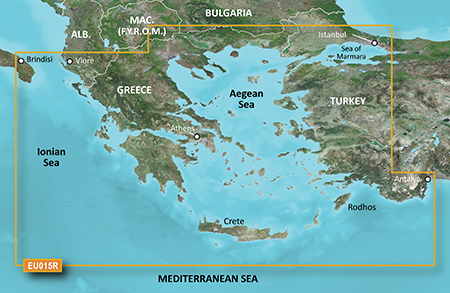
 BlueChart g2 - HEU015R - Aegean Sea & Sea of Marmara 2015.0 [16.50]
BlueChart g2 - HEU015R - Aegean Sea & Sea of Marmara 2015.0 (16.50)
See your vessels precise, on-chart position in relation to navaids, coastal features, anchorages, obstructions, waterways, restricted areas and more with this detailed marine mapping data.
- Shaded depth contours, coastlines, spot soundings, navaids, port plans, wrecks, obstructions, intertidal zones, restricted areas and IALA symbols.
- Seamless transitions between zoom levels and more continuity across chart boundaries.
- Standard 2-D direct overhead or 3-D over the bow map perspective for easy chart reading and orientation.
- Safety Shading* enables contour shading for all depth contours shallower than your defined safe depths.
- Fishing Charts* to scope out bottom contours and depth soundings with less visual clutter on the display.
- Plan and organize routes from your computer with HomePort (sold separately).
Coverage
Including all of the Greek coast and Aegean Sea; Turkey from Istanbul and Sea of Marmara to Antalya; and Brindisi, Italy.
FID 3647, PID 1, region 2,21
Locked Image:
UnLocked Image:
 PiEtU Reviewed by PiEtU on . BlueChart g2 - HEU015R - Aegean Sea & Sea of Marmara 2015.0 [16.50] BlueChart g2 - HEU015R - Aegean Sea & Sea of Marmara 2015.0 (16.50) See your vessels precise, on-chart position in relation to navaids, coastal features, anchorages, obstructions, waterways, restricted areas and more with this detailed marine mapping data. Shaded depth contours, coastlines, spot soundings, navaids, port plans, wrecks, obstructions, intertidal zones, restricted areas and IALA symbols. Seamless transitions between zoom levels and more continuity across chart Rating: 5
-
The Following 7 Users Say Thank You to PiEtU For This Useful Post:
- [ Click To Expand ]
-
-
15th May 2016, 01:33 PM #2
Hello from a senior member, sry but the links are dead. Any chance to ge them from elsewhere ?
-
1st February 2018, 12:40 AM #3
Links are dead,please repost them
-
26th May 2019, 01:30 AM #4

Re-uploaded the unlocked .img file split over 500Mb .rar files to zippyshare site.
Uploaded .rar files set to private during upload to file sharing site and requires
password to unpack. Do not share or post URL to other sites.
password=gpsurl
Unlocked map file
HEU015R
Enjoy.
-
The Following 1 Users Say Thank You to dennisolof For This Useful Post:
- [ Click To Expand ]
-
wpfakh (10th June 2019)
-
16th June 2019, 04:50 PM #5

Dear dennisolof
There is only one link (Size: 175.99 MB) in your last post.
Please, please post it again all the links for the unlocked .img BlueChart g2 - HEU015R - Aegean Sea & Sea of Marmara 2015.0 (16.50)
Thank you very much!
-
16th June 2019, 10:23 PM #6
Last edited by AnnoyedOne; 17th June 2019 at 02:25 AM. Reason: Added info from GMapTool
-
The Following 1 Users Say Thank You to AnnoyedOne For This Useful Post:
- [ Click To Expand ]
-
dimbait (17th June 2019)
-
17th June 2019, 08:38 AM #7
-
3rd August 2019, 06:39 PM #8
Hi! is there any way to get it reuploaded? zippyshare does not seem to work anymore. Thanks!
-
6th August 2020, 02:29 AM #9
Hello,
can you ask for a current link?
-
28th March 2021, 04:22 AM #10
Re-uploaded this release
Enjoy.
![BlueChart g2 - HEU015R - Aegean Sea & Sea of Marmara 2015.0 [16.50]](https://www.hostdel.com/banners/RDP/300X250.gif)

 Register To Reply
Advertisements
![BlueChart g2 - HEU015R - Aegean Sea & Sea of Marmara 2015.0 [16.50]](https://www.hostdel.com/banners/Dedicated/728x90.gif)

Suggested Articles:
![BlueChart g2 - HEU015R - Aegean Sea & Sea of Marmara 2015.0 [16.50]](https://www.hostdel.com/banners/GameServer/728x90.gif)

![BlueChart g2 - HEU015R - Aegean Sea & Sea of Marmara 2015.0 [16.50]](https://www.hostdel.com/banners/Email/300X250.gif)


 Staff Online
![BlueChart g2 - HEU015R - Aegean Sea & Sea of Marmara 2015.0 [16.50]](https://www.hostdel.com/banners/Dedicated/300x600.gif)
iGO HERE EUROPE 2024.Q2
Me falta el codigo para extraer el archivo. Mapa...