


![BlueChart g2 Vision - VEU451S - Ligurian Sea-Corsica & Sardinia 2014.5 [16.00]](https://www.hostdel.com/banners/Hosting/728x90.gif)
Results 1 to 7 of 7
-
1st April 2015, 07:17 AM #1
 Garmin Expert
Supporter

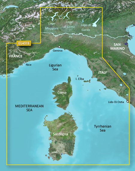
 BlueChart g2 Vision - VEU451S - Ligurian Sea-Corsica & Sardinia 2014.5 [16.00]
BlueChart g2 Vision - VEU451S - Ligurian Sea-Corsica & Sardinia 2014.5 (16.00)
See your vessels precise, on-chart position in relation to navaids, coastal features and restricted areas with premium features found in this detailed marine mapping data. Includes all of the features of our BlueChart® g2 product, plus 3-D perspective above and below the waterline, Auto Guidance, high-resolution imagery, and aerial photos of ports, harbors, marinas and landmarks.
- Shaded depth contours, coastlines, spot soundings, navaids, port plans, wrecks, obstructions, intertidal zones, restricted areas and IALA symbols.
- Seamless transitions between zoom levels and more continuity across chart boundaries.
- High resolution satellite imagery for a realistic view of the land and water.
- Aerial photos of ports, harbors, marinas, waterways, navigational landmarks and other POIs.
- Auto Guidance technology searches chart data to suggest the best passage to a destination.
- MarinerEye view 3-D perspective for a quick, easy position fix.
- FishEye view 3-D perspective for an underwater view of the sea floor.
- Safety Shading* enables contour shading for all depth contours shallower than your defined safe depths.
- Fishing Charts* to scope out bottom contours and depth soundings with less visual clutter on the display.
- Plan and organize routes from your computer with HomePort (sold separately).
Coverage
Detailed coverage of the Mediterranean coast from Le Lavandou, FR to Lido di Ostia, IT including Monaco and complete coverage of Corse and Sardegna. Also includes coverage of Lago Maggiore, Lago d'Iseo, Lago di Como and Lago d'Garda in Italy.
FID: 3480, PID: 1, RID: 5, VID: 2
Locked Image:
UnLocked Image:
 PiEtU Reviewed by PiEtU on . BlueChart g2 Vision - VEU451S - Ligurian Sea-Corsica & Sardinia 2014.5 [16.00] BlueChart g2 Vision - VEU451S - Ligurian Sea-Corsica & Sardinia 2014.5 (16.00) See your vessels precise, on-chart position in relation to navaids, coastal features and restricted areas with premium features found in this detailed marine mapping data. Includes all of the features of our BlueChart® g2 product, plus 3-D perspective above and below the waterline, Auto Guidance, high-resolution imagery, and aerial photos of ports, harbors, marinas and landmarks. Shaded depth contours, Rating: 5
-
7th April 2018, 12:06 AM #2
hi...please reupp this ....
thanks
-
26th May 2019, 12:48 AM #3

Re-uploaded the unlocked .img file split over 500Mb .rar files to zippyshare site.
Uploaded .rar files set to private during upload to file sharing site and requires
password to unpack. Do not share or post URL to other sites.
password=gpsurl
Unlocked map files
VEU451S
Enjoy.
-
The Following 2 Users Say Thank You to dennisolof For This Useful Post:
- [ Click To Expand ]
-
-
23rd May 2020, 04:12 AM #4
pls reupp thanks
-
28th March 2021, 04:24 AM #5
Re-uploaded this release
Enjoy.
-
2nd May 2022, 09:29 PM #6
Any chance you can repost? All links are expired
-
16th November 2022, 10:38 PM #7
Re-uploaded this release
Enjoy.
-
The Following 1 Users Say Thank You to dennisolof For This Useful Post:
- [ Click To Expand ]
-
FireFox58 (20th November 2022)
![BlueChart g2 Vision - VEU451S - Ligurian Sea-Corsica & Sardinia 2014.5 [16.00]](https://www.hostdel.com/banners/RDP/300X250.gif)

 Register To Reply
Advertisements
![BlueChart g2 Vision - VEU451S - Ligurian Sea-Corsica & Sardinia 2014.5 [16.00]](https://www.hostdel.com/banners/Dedicated/728x90.gif)
Suggested Articles:
![BlueChart g2 Vision - VEU451S - Ligurian Sea-Corsica & Sardinia 2014.5 [16.00]](https://www.hostdel.com/banners/GameServer/728x90.gif)

![BlueChart g2 Vision - VEU451S - Ligurian Sea-Corsica & Sardinia 2014.5 [16.00]](https://www.hostdel.com/banners/Email/300X250.gif)


 Staff Online
![BlueChart g2 Vision - VEU451S - Ligurian Sea-Corsica & Sardinia 2014.5 [16.00]](https://www.hostdel.com/banners/Dedicated/300x600.gif)
City Navigator Europe NT 2025.10...
IMO I would get a 32GB SD card they are a few...