


![BlueChart g2 Vision - VUS512L - Mid-Atlantic 2014.5 [16.00]](https://www.hostdel.com/banners/Hosting/728x90.gif)
Results 1 to 9 of 9
-
1st April 2015, 05:46 AM #1
 Garmin Expert
Supporter

 BlueChart g2 Vision - VUS512L - Mid-Atlantic 2014.5 [16.00]
BlueChart g2 Vision - VUS512L - Mid-Atlantic 2014.5 (16.00)
See your vessel’s precise, on-chart position in relation to navaids, coastal features and restricted areas with premium features found in this detailed marine mapping data. Includes all of the features of our BlueChart® g2 product, plus 3-D perspective above and below the waterline, Auto Guidance, high-resolution imagery, and aerial photos of ports, harbors, marinas and landmarks.
- Shaded depth contours, coastlines, spot soundings, navaids, port plans, wrecks, obstructions, intertidal zones, restricted areas and IALA symbols.
- Seamless transitions between zoom levels and more continuity across chart boundaries.
- High resolution satellite imagery for a realistic view of the land and water.
- Aerial photos of ports, harbors, marinas, waterways, navigational landmarks and other POIs.
- Auto Guidance technology searches chart data to suggest the best passage to a destination.
- MarinerEye view 3-D perspective for a quick, easy position fix.
- FishEye view 3-D perspective for an underwater view of the sea floor.
- Safety Shading* enables contour shading for all depth contours shallower than your defined safe depths.
- Fishing Charts* to scope out bottom contours and depth soundings with less visual clutter on the display.
- Plan and organize routes from your computer with HomePort™.
Coverage
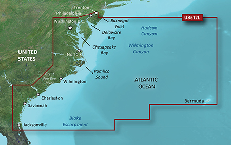
Coverage of the east Coast from Barnegat Inlet, NJ through Jacksonville, FL, to Bermuda. Coverage includes the Delaware River to Trenton, NJ; the Chesepeake Bay in full; the Albemarle and Pamlico Sounds in full; Cape Fear, NC; the Savannah R. to Augusta, GA; and the St. Johns R. to Hastings, FL. Bathymetric coverage from Hudson Canyon to the Blake Escarpment, including the Wilmington, Baltimore and Washington Canyons, Charleston Valley, and the Savannah Seachannel.
FID 3479, PID 1, region 4,29

 PiEtU Reviewed by PiEtU on . BlueChart g2 Vision - VUS512L - Mid-Atlantic 2014.5 [16.00] BlueChart g2 Vision - VUS512L - Mid-Atlantic 2014.5 (16.00) See your vessel’s precise, on-chart position in relation to navaids, coastal features and restricted areas with premium features found in this detailed marine mapping data. Includes all of the features of our BlueChart® g2 product, plus 3-D perspective above and below the waterline, Auto Guidance, high-resolution imagery, and aerial photos of ports, harbors, marinas and landmarks. Shaded depth contours, coastlines, spot Rating: 5
-
31st May 2017, 09:24 AM #2
Please update links. Thanks.
-
2nd November 2017, 09:45 PM #3
-
10th November 2017, 08:13 PM #4
Down Leider viele Karten sind down
-
6th July 2018, 06:34 AM #5
Anyone have a working link?
-
26th May 2019, 12:43 AM #6

Re-uploaded this release
Enjoy.Last edited by dennisolof; 22nd March 2021 at 08:06 PM.
-
The Following 3 Users Say Thank You to dennisolof For This Useful Post:
- [ Click To Expand ]
-
-
28th January 2021, 03:31 AM #7
Viliam, need it ? I can put it up again.
-
4th February 2021, 06:08 AM #8
Could you please put it back up dennisolof? Thank you.
-
22nd February 2021, 04:31 AM #9
Updated my original post, you can now download the files :-)
-
The Following 1 Users Say Thank You to dennisolof For This Useful Post:
- [ Click To Expand ]
-
timp4411 (22nd February 2021)
![BlueChart g2 Vision - VUS512L - Mid-Atlantic 2014.5 [16.00]](https://www.hostdel.com/banners/RDP/300X250.gif)

 Register To Reply
Advertisements
![BlueChart g2 Vision - VUS512L - Mid-Atlantic 2014.5 [16.00]](https://www.hostdel.com/banners/Dedicated/728x90.gif)
Suggested Articles:
![BlueChart g2 Vision - VUS512L - Mid-Atlantic 2014.5 [16.00]](https://www.hostdel.com/banners/GameServer/728x90.gif)

![BlueChart g2 Vision - VUS512L - Mid-Atlantic 2014.5 [16.00]](https://www.hostdel.com/banners/Email/300X250.gif)


 Staff Online
![BlueChart g2 Vision - VUS512L - Mid-Atlantic 2014.5 [16.00]](https://www.hostdel.com/banners/Dedicated/300x600.gif)
City Navigator Europe NT 2025.10...
I would get a 32GB SD card they are only a few...