


![BlueChart g2 Vision - VAE002R - Yellow Sea 2014.5 [16.00]](https://www.hostdel.com/banners/Hosting/728x90.gif)
Results 1 to 10 of 13
-
14th January 2015, 06:08 PM #1
 Garmin Expert
Supporter

 BlueChart g2 Vision - VAE002R - Yellow Sea 2014.5 [16.00]
BlueChart g2 Vision - VAE002R - Yellow Sea 2014.5 (16.00)
See your vessel’s precise, on-chart position in relation to navaids, coastal features and restricted areas with premium features found in this detailed marine mapping data. Includes all of the features of our BlueChart® g2 product, plus 3-D perspective above and below the waterline, Auto Guidance, high-resolution imagery, and aerial photos of ports, harbors, marinas and landmarks.
- Shaded depth contours, coastlines, spot soundings, navaids, port plans, wrecks, obstructions, intertidal zones, restricted areas and IALA symbols.
- Seamless transitions between zoom levels and more continuity across chart boundaries.
- High resolution satellite imagery for a realistic view of the land and water.
- Aerial photos of ports, harbors, marinas, waterways, navigational landmarks and other POIs.
- Auto Guidance technology searches chart data to suggest the best passage to a destination.
- MarinerEye view 3-D perspective for a quick, easy position fix.
- FishEye view 3-D perspective for an underwater view of the sea floor.
- Safety Shading* enables contour shading for all depth contours shallower than your defined safe depths.
- Fishing Charts* to scope out bottom contours and depth soundings with less visual clutter on the display.
- Plan and organize routes from your computer with HomePort™ (sold separately).
Coverage
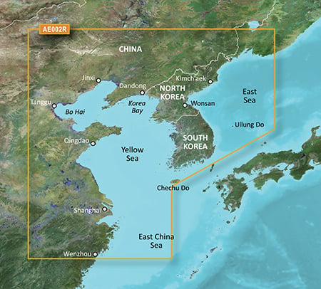
General coverage of the Chinese coast from Wenzhou to Dandong; the South Korean coast in its entirety; the full west coast of North Korea and the east coast south of Kimch'aek. Included in this overall general coverage are numerous detailed charts covering areas in China such as Shanghai, Qingdao, and Dalian; and also Nampo, N.Kor., and Pusan, S. Kor
FID: 3852, PID: 1, RID: 3, VID: 2
Locked Image:
UnLocked Image:
 PiEtU Reviewed by PiEtU on . BlueChart g2 Vision - VAE002R - Yellow Sea 2014.5 [16.00] BlueChart g2 Vision - VAE002R - Yellow Sea 2014.5 (16.00) See your vessel’s precise, on-chart position in relation to navaids, coastal features and restricted areas with premium features found in this detailed marine mapping data. Includes all of the features of our BlueChart® g2 product, plus 3-D perspective above and below the waterline, Auto Guidance, high-resolution imagery, and aerial photos of ports, harbors, marinas and landmarks. Shaded depth contours, coastlines, spot Rating: 5
-
2nd April 2016, 08:20 AM #2
Please update links. Thanks.
-
1st November 2017, 02:40 PM #3

Hello! Is it possible to update the links?
-
24th July 2018, 09:15 PM #4
please reupload,thank you
-
10th October 2018, 03:43 PM #5
Can this map be used with GPSmap 722 with firmware v12? Thanks
-
25th May 2019, 01:35 AM #6

Re-uploaded this release
Enjoy.Last edited by dennisolof; 22nd March 2021 at 06:49 PM.
-
The Following 1 Users Say Thank You to dennisolof For This Useful Post:
- [ Click To Expand ]
-
ta1234 (19th June 2021)
-
19th July 2019, 01:07 AM #7
VAE002R.img file has not mount. UltraISO and win32DiskImager.
Are there four zip files?
-
22nd July 2019, 07:08 PM #8
Yes, there are four .zip files, and when you unzip the content there is one unlocked .img file and I do not think you can mount it they way you are trying to. It is a .img file for garmin devices or garmin type software that can read the file. It is not a regular .img file but I am not sure about that.
-
13th November 2020, 07:09 AM #9
Please update links. Thanks.
-
28th January 2021, 03:29 AM #10
kenbaby, do you want the map. I could put it up again for you.
![BlueChart g2 Vision - VAE002R - Yellow Sea 2014.5 [16.00]](https://www.hostdel.com/banners/RDP/300X250.gif)

 Register To Reply
Advertisements
![BlueChart g2 Vision - VAE002R - Yellow Sea 2014.5 [16.00]](https://www.hostdel.com/banners/Dedicated/728x90.gif)
Suggested Articles:
![BlueChart g2 Vision - VAE002R - Yellow Sea 2014.5 [16.00]](https://www.hostdel.com/banners/GameServer/728x90.gif)

![BlueChart g2 Vision - VAE002R - Yellow Sea 2014.5 [16.00]](https://www.hostdel.com/banners/Email/300X250.gif)


 Staff Online
![BlueChart g2 Vision - VAE002R - Yellow Sea 2014.5 [16.00]](https://www.hostdel.com/banners/Dedicated/300x600.gif)
2023.Q2 Here Australia,New Zealand
Australia New_Zealand HERE 2024.Q2 please