


![BlueChart g2 Vision - VEU016R - Mediterranean Southeast 2014.5 [16.00]](https://www.hostdel.com/banners/Hosting/728x90.gif)
Results 1 to 3 of 3
-
16th December 2014, 02:26 AM #1
 Garmin Expert
Supporter

 BlueChart g2 Vision - VEU016R - Mediterranean Southeast 2014.5 [16.00]
BlueChart g2 Vision - VEU016R - Mediterranean Southeast 2014.5 (16.00)
See your vessels precise, on-chart position in relation to navaids, coastal features and restricted areas with premium features found in this detailed marine mapping data. Includes all of the features of our BlueChart® g2 product, plus 3-D perspective above and below the waterline, Auto Guidance, high-resolution imagery, and aerial photos of ports, harbors, marinas and landmarks.
- Shaded depth contours, coastlines, spot soundings, navaids, port plans, wrecks, obstructions, intertidal zones, restricted areas and IALA symbols.
- Seamless transitions between zoom levels and more continuity across chart boundaries.
- High resolution satellite imagery for a realistic view of the land and water.
- Aerial photos of ports, harbors, marinas, waterways, navigational landmarks and other POIs.
- Auto Guidance technology searches chart data to suggest the best passage to a destination.
- MarinerEye view 3-D perspective for a quick, easy position fix.
- FishEye view 3-D perspective for an underwater view of the sea floor.
- Safety Shading* enables contour shading for all depth contours shallower than your defined safe depths.
- Fishing Charts* to scope out bottom contours and depth soundings with less visual clutter on the display.
- Plan and organize routes from your computer with HomePort.
Coverage
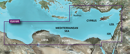
From Güllük, Turkey east to include Cyprus, Syria, Lebanon and Israel, then west to Misratah, Libya.
FID: 3481, PID: 1, RID: 2, VID: 22
Locked Image:
UnLocked Image:
 PiEtU Reviewed by PiEtU on . BlueChart g2 Vision - VEU016R - Mediterranean Southeast 2014.5 [16.00] BlueChart g2 Vision - VEU016R - Mediterranean Southeast 2014.5 (16.00) See your vessels precise, on-chart position in relation to navaids, coastal features and restricted areas with premium features found in this detailed marine mapping data. Includes all of the features of our BlueChart® g2 product, plus 3-D perspective above and below the waterline, Auto Guidance, high-resolution imagery, and aerial photos of ports, harbors, marinas and landmarks. Shaded depth contours, coastlines, Rating: 5
-
The Following 1 Users Say Thank You to PiEtU For This Useful Post:
- [ Click To Expand ]
-
Stellatjejen (29th September 2017)
-
6th February 2018, 07:53 PM #2
link is not working
-
5th July 2019, 10:27 PM #3
anyone have a new link???
![BlueChart g2 Vision - VEU016R - Mediterranean Southeast 2014.5 [16.00]](https://www.hostdel.com/banners/RDP/300X250.gif)

 Register To Reply
Advertisements
![BlueChart g2 Vision - VEU016R - Mediterranean Southeast 2014.5 [16.00]](https://www.hostdel.com/banners/Dedicated/728x90.gif)
Suggested Articles:
![BlueChart g2 Vision - VEU016R - Mediterranean Southeast 2014.5 [16.00]](https://www.hostdel.com/banners/GameServer/728x90.gif)

![BlueChart g2 Vision - VEU016R - Mediterranean Southeast 2014.5 [16.00]](https://www.hostdel.com/banners/Email/300X250.gif)


 Staff Online
![BlueChart g2 Vision - VEU016R - Mediterranean Southeast 2014.5 [16.00]](https://www.hostdel.com/banners/Dedicated/300x600.gif)
City Navigator North America NT...
thank you, I will patiently wait for 3d map for...