


![BlueChart g2 - HCA015R - Canada g2 2014.0 [15.50]](https://www.hostdel.com/banners/Hosting/728x90.gif)
Results 1 to 7 of 7
-
11th October 2014, 03:19 PM #1
 Garmin Expert
Supporter

 BlueChart g2 - HCA015R - Canada g2 2014.0 [15.50]
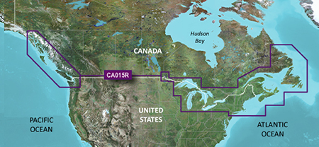
BlueChart g2 - HCA015R - Canada g2 2014.0 (15.50)
See your vessels precise, on-chart position in relation to navaids, coastal features, anchorages, obstructions, waterways, restricted areas and more with this detailed marine mapping data.
- Shaded depth contours, coastlines, spot soundings, navaids, port plans, wrecks, obstructions, intertidal zones, restricted areas and IALA symbols.
- Seamless transitions between zoom levels and more continuity across chart boundaries.
- Standard 2-D direct overhead or 3-D over the bow map perspective for easy chart reading and orientation.
- Safety Shading* enables contour shading for all depth contours shallower than your defined safe depths.
- Fishing Charts* to scope out bottom contours and depth soundings with less visual clutter on the display.
- Plan and organize routes from your computer with HomePort (sold separately).
Coverage
Provides detailed coastal coverage of the North America east Coast from Nain, NL to Raritan Bay, NY featuring Newfoundland, Île d'Anticosti, New York Harbor, and full U.S. and Canadian coverage of the Great Lakes in their entirety. The North American west Coast is covered from Glacier Bay, AK to Aberdeen, WA featuring British Columbia, Vancouver, the Queen Charlotte Islands, and Puget Sound.
FID: 3252, PID: 1, RID: 19, VID: 4
Locked Image:
UnLocked Image:
 PiEtU Reviewed by PiEtU on . BlueChart g2 - HCA015R - Canada g2 2014.0 [15.50] BlueChart g2 - HCA015R - Canada g2 2014.0 (15.50) See your vessels precise, on-chart position in relation to navaids, coastal features, anchorages, obstructions, waterways, restricted areas and more with this detailed marine mapping data. Shaded depth contours, coastlines, spot soundings, navaids, port plans, wrecks, obstructions, intertidal zones, restricted areas and IALA symbols. Seamless transitions between zoom levels and more continuity across chart boundaries. Rating: 5
-
28th October 2018, 10:51 PM #2
"Invalid download link" :-(
Any chance of a reupload? Thanks!!!
-
5th July 2019, 10:28 PM #3
anyone have a new link please??
-
6th July 2019, 12:04 AM #4

As far as I have been on this forum, I have not seen Pietu ever on here recently. These maps are around but as far this forum goes, you won't find these maps here without people putting some effort into looking for them.
-
The Following 1 Users Say Thank You to DXOS3 For This Useful Post:
- [ Click To Expand ]
-
Simeric (6th July 2019)
-
6th July 2019, 07:53 AM #5
Garmin Mod
Supporter
![BlueChart g2 - HCA015R - Canada g2 2014.0 [15.50]](http://www.gpsurl.com/images/ranks/moderator.png)
I see you newly joined and are asking for totally unrelated BlueCharts else where, what vessel do you have that you need all these?
BlueChart g2 - HCA015R - Canada
BlueChart g2 Vision - VEU016R - Mediterranean Southeast
Australia & New Zealand HXPC024R
BlueChart g2 Vision - VPC022R - East Coast Australia
BlueChart g2 Vision VPC019R - Polynesia v2013.51 (v15.01)Last edited by Garmin_Nuvi; 6th July 2019 at 10:33 AM.
-
The Following 1 Users Say Thank You to Garmin_Nuvi For This Useful Post:
- [ Click To Expand ]
-
DXOS3 (6th July 2019)
-
6th July 2019, 06:39 PM #6
a bluewater sailboat that's going places :-)
-
18th August 2019, 05:02 PM #7
Did you get a link for BlueChart g2 - HCA015R - Canada ?
![BlueChart g2 - HCA015R - Canada g2 2014.0 [15.50]](https://www.hostdel.com/banners/RDP/300X250.gif)

 Register To Reply
Advertisements
![BlueChart g2 - HCA015R - Canada g2 2014.0 [15.50]](https://www.hostdel.com/banners/Dedicated/728x90.gif)
Suggested Articles:
![BlueChart g2 - HCA015R - Canada g2 2014.0 [15.50]](https://www.hostdel.com/banners/GameServer/728x90.gif)

![BlueChart g2 - HCA015R - Canada g2 2014.0 [15.50]](https://www.hostdel.com/banners/Email/300X250.gif)


 Staff Online
![BlueChart g2 - HCA015R - Canada g2 2014.0 [15.50]](https://www.hostdel.com/banners/Dedicated/300x600.gif)
City Navigator Europe NT 2025.10...
New map requires 14 GB......... with GE & the...