


![BlueChart g2 - HEU710L - Skagerrak-Denmark-Germany 2014.0 [15.50]](https://www.hostdel.com/banners/Hosting/728x90.gif)
Results 1 to 4 of 4
-
6th August 2014, 11:38 AM #1
 Garmin Expert
Supporter

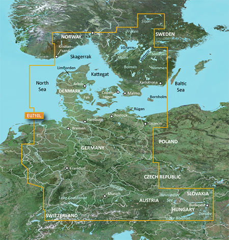
 BlueChart g2 - HEU710L - Skagerrak-Denmark-Germany 2014.0 [15.50]
BlueChart g2 - HEU710L - Skagerrak-Denmark-Germany 2014.0 (15.50)
See your vessels precise, on-chart position in relation to navaids, coastal features, anchorages, obstructions, waterways, restricted areas and more with this detailed marine mapping data.
- Shaded depth contours, coastlines, spot soundings, navaids, port plans, wrecks, obstructions, intertidal zones, restricted areas and IALA symbols.
- Seamless transitions between zoom levels and more continuity across chart boundaries.
- Standard 2-D direct overhead or 3-D over the bow map perspective for easy chart reading and orientation.
- Safety Shading* enables contour shading for all depth contours shallower than your defined safe depths.
- Fishing Charts* to scope out bottom contours and depth soundings with less visual clutter on the display.
- Plan and organize routes from your computer with HomePort (sold separately).
Coverage
Detailed coverage of the coasts of Denmark, Germany, and southern Norway and Sweden from Kristiansand, NO to Karlskrona, SE including Oslo, NO along with Malmö and Trelleborg, SE, the Telemark Canal and Lakes Vänern, Vättern, Mjörn, Sommen, Nommen, Siljan and Bolmen, the Skagerrak and the Kattegat. Coverage also includes all major inland canals and rivers of Germany including the Mittelland Canal, the Rhine River, the Main River to Bamberg, the Danube River from Kelheim to Passau, the Saar River, the Moselle River to Metz, FR and the Ems River to Papenburg, the Weser River to Minden, the Elbe River to Dresden, Lake Constance, Lake Balaton and the Neusiedler See.
FID: 3257, PID: 1, RID: 4, VID: 16
Locked Image:
[SPOILER=Download File:-][/SPOILER]
UnLocked Image:
[SPOILER=Download File:-][/SPOILER]
 PiEtU Reviewed by PiEtU on . BlueChart g2 - HEU710L - Skagerrak-Denmark-Germany 2014.0 [15.50] BlueChart g2 - HEU710L - Skagerrak-Denmark-Germany 2014.0 (15.50) See your vessels precise, on-chart position in relation to navaids, coastal features, anchorages, obstructions, waterways, restricted areas and more with this detailed marine mapping data. Shaded depth contours, coastlines, spot soundings, navaids, port plans, wrecks, obstructions, intertidal zones, restricted areas and IALA symbols. Seamless transitions between zoom levels and more continuity across chart Rating: 5
-
24th July 2018, 09:13 PM #2
please reupload,thank you
-
25th May 2019, 04:55 AM #3

Re-uploaded the unlocked .img file split over 500Mb .rar files to zippyshare site.
Uploaded .rar files set to private during upload to file sharing site and requires
password to unpack. Do not share or post URL to other sites.
password=gpsurl
Unlocked map file
HEU710L
Enjoy.
-
28th March 2021, 05:22 AM #4
Re-uploaded this release
Enjoy.
![BlueChart g2 - HEU710L - Skagerrak-Denmark-Germany 2014.0 [15.50]](https://www.hostdel.com/banners/RDP/300X250.gif)

 Register To Reply
Advertisements
![BlueChart g2 - HEU710L - Skagerrak-Denmark-Germany 2014.0 [15.50]](https://www.hostdel.com/banners/Dedicated/728x90.gif)
Suggested Articles:
![BlueChart g2 - HEU710L - Skagerrak-Denmark-Germany 2014.0 [15.50]](https://www.hostdel.com/banners/GameServer/728x90.gif)

![BlueChart g2 - HEU710L - Skagerrak-Denmark-Germany 2014.0 [15.50]](https://www.hostdel.com/banners/Email/300X250.gif)


 Staff Online
![BlueChart g2 - HEU710L - Skagerrak-Denmark-Germany 2014.0 [15.50]](https://www.hostdel.com/banners/Dedicated/300x600.gif)
2023.Q2 Here Australia,New Zealand
Australia New_Zealand HERE 2024.Q2 please