


![BlueChart g2 Vision - VEU479S - Portugal 2014.0 [15.50]](https://www.hostdel.com/banners/Hosting/728x90.gif)
Results 1 to 6 of 6
-
21st July 2014, 04:51 PM #1
 Garmin Expert
Supporter

 BlueChart g2 Vision - VEU479S - Portugal 2014.0 [15.50]
BlueChart g2 Vision - VEU479S - Portugal 2014.0 (15.50)
See your vessels precise, on-chart position in relation to navaids, coastal features and restricted areas with premium features found in this detailed marine mapping data. Includes all of the features of our BlueChart® g2 product, plus 3-D perspective above and below the waterline, Auto Guidance, high-resolution imagery, and aerial photos of ports, harbors, marinas and landmarks.
- Shaded depth contours, coastlines, spot soundings, navaids, port plans, wrecks, obstructions, intertidal zones, restricted areas and IALA symbols.
- Seamless transitions between zoom levels and more continuity across chart boundaries.
- High resolution satellite imagery for a realistic view of the land and water.
- Aerial photos of ports, harbors, marinas, waterways, navigational landmarks and other POIs.
- Auto Guidance technology searches chart data to suggest the best passage to a destination.
- MarinerEye view 3-D perspective for a quick, easy position fix.
- FishEye view 3-D perspective for an underwater view of the sea floor.
- Safety Shading* enables contour shading for all depth contours shallower than your defined safe depths.
- Fishing Charts* to scope out bottom contours and depth soundings with less visual clutter on the display.
- Plan and organize routes from your computer with HomePort (sold separately).
Coverage
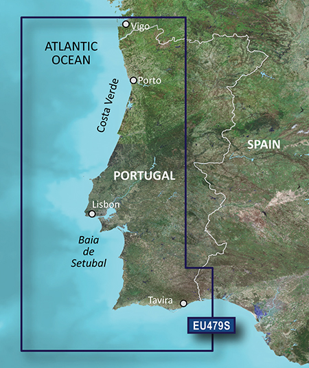
From Vigo, Spain Atlantic coast to Cabo de Sao Vicente to Ayamonte. Also including Viana Do Castelo, Porto, Aveiro, Figueira Da Foz, Nazaré, Peniche, Lisbon, Sesimbra, Sines, Ponta De Sagres, Lagos, Portimao, Vilamoura and Faro.
FID: 3246, PID: 1, RID: 5, VID: 45
Locked Image:
UnLocked Image:
 PiEtU Reviewed by PiEtU on . BlueChart g2 Vision - VEU479S - Portugal 2014.0 [15.50] BlueChart g2 Vision - VEU479S - Portugal 2014.0 (15.50) See your vessels precise, on-chart position in relation to navaids, coastal features and restricted areas with premium features found in this detailed marine mapping data. Includes all of the features of our BlueChart® g2 product, plus 3-D perspective above and below the waterline, Auto Guidance, high-resolution imagery, and aerial photos of ports, harbors, marinas and landmarks. Shaded depth contours, coastlines, spot soundings, Rating: 5
-
16th November 2016, 03:13 AM #2
updates for this map anyone?
thank you
-
20th August 2018, 04:08 PM #3
Hi any update in the urls? they dont work
-
25th May 2019, 01:24 AM #4

Re-uploaded the unlocked .img file to zippyshare site.
Uploaded .rar files set to private during upload to file sharing site and
requires password to unpack. Do not share or post URL to other sites.
password=gpsurl
Unlocked map file
VEU479S-UL
Enjoy.Last edited by dennisolof; 25th May 2019 at 05:02 AM.
-
4th August 2020, 09:34 PM #5
Hello. Can you reupload it again? Thank you.
-
28th March 2021, 04:23 AM #6
Re-uploaded this release
Enjoy.
-
The Following 1 Users Say Thank You to dennisolof For This Useful Post:
- [ Click To Expand ]
-
ta1234 (18th June 2021)
![BlueChart g2 Vision - VEU479S - Portugal 2014.0 [15.50]](https://www.hostdel.com/banners/RDP/300X250.gif)

 Register To Reply
Advertisements
![BlueChart g2 Vision - VEU479S - Portugal 2014.0 [15.50]](https://www.hostdel.com/banners/Dedicated/728x90.gif)
Suggested Articles:
![BlueChart g2 Vision - VEU479S - Portugal 2014.0 [15.50]](https://www.hostdel.com/banners/GameServer/728x90.gif)

![BlueChart g2 Vision - VEU479S - Portugal 2014.0 [15.50]](https://www.hostdel.com/banners/Email/300X250.gif)


 Staff Online
![BlueChart g2 Vision - VEU479S - Portugal 2014.0 [15.50]](https://www.hostdel.com/banners/Dedicated/300x600.gif)
Garmin City Navigator Europe NTU...
Welcome to the forum. Your device uses these NTU...