


![BlueChart g2 Vision - VAE009R - Sin/Mal/Indonesia 2014.0 [15.50]](https://www.hostdel.com/banners/Hosting/728x90.gif)
Results 1 to 10 of 13
-
27th March 2014, 07:53 AM #1
 Garmin Master

 BlueChart g2 Vision - VAE009R - Sin/Mal/Indonesia 2014.0 [15.50]
BlueChart g2 Vision - VAE009R - Sin/Mal/Indonesia 2014.0 (15.50)
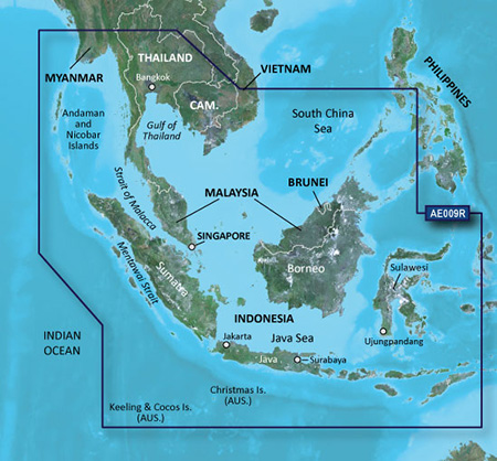
See your vessel’s precise, on-chart position in relation to navaids, coastal features and restricted areas with premium features found in this detailed marine mapping data. Includes all of the features of our BlueChart® g2 product, plus 3-D perspective above and below the waterline, Auto Guidance, high-resolution imagery, and aerial photos of ports, harbors, marinas and landmarks.
- Shaded depth contours, coastlines, spot soundings, navaids, port plans, wrecks, obstructions, intertidal zones, restricted areas and IALA symbols.
- Seamless transitions between zoom levels and more continuity across chart boundaries.
- High resolution satellite imagery for a realistic view of the land and water.
- Aerial photos of ports, harbors, marinas, waterways, navigational landmarks and other POIs.
- Auto Guidance technology searches chart data to suggest the best passage to a destination.
- MarinerEye view 3-D perspective for a quick, easy position fix.
- FishEye view 3-D perspective for an underwater view of the sea floor.
- Safety Shading* enables contour shading for all depth contours shallower than your defined safe depths.
- Fishing Charts* to scope out bottom contours and depth soundings with less visual clutter on the display.
- Plan and organize routes from your computer with HomePort™ (sold separately).
Coverage
Coverage of the entire Malay Peninsula; Thailand; Cambodia; southern Vietnam including Ho Chi Minh City and the Mekong Delta; Brunei and Indonesia west of Timor. Islands covered include Java, Sumatra, Sulawesi and Borneo, Indonesia; Christmas Islands, Keeling Islands, Cocos Islands and the Andaman and Nicobar Islands.
FID: 3250, PID: 1, RID: 3, VID: 30
Locked Image:
UnLocked Image:
 p33dro Reviewed by p33dro on . BlueChart g2 Vision - VAE009R - Sin/Mal/Indonesia 2014.0 [15.50] BlueChart g2 Vision - VAE009R - Sin/Mal/Indonesia 2014.0 (15.50) See your vessel’s precise, on-chart position in relation to navaids, coastal features and restricted areas with premium features found in this detailed marine mapping data. Includes all of the features of our BlueChart® g2 product, plus 3-D perspective above and below the waterline, Auto Guidance, high-resolution imagery, and aerial photos of ports, harbors, marinas and landmarks. Shaded depth contours, coastlines, spot Rating: 5When nothing goes right, go left.
-
24th February 2018, 10:51 PM #2
please reupload
-
24th July 2018, 09:13 PM #3
please reupload,thank you
-
11th August 2018, 12:51 AM #4
please reupload, tnx
-
25th May 2019, 03:13 AM #5

Re-uploaded the unlocked .img file split over 500Mb .rar files to zippyshare site.
Uploaded .rar files set to private during upload to file sharing site and requires
password to unpack. Do not share or post URL to other sites.
password=gpsurl
Unlocked map files
VAE009R
Enjoy.Last edited by dennisolof; 25th May 2019 at 04:58 AM.
-
13th August 2020, 09:47 PM #6
Dear friend I am looking for Garmin G2 Blue chart vision VAE009R Sin/Malaysia /Indonesia, try to download but the link given found files was deleted.Is any new link/mirror to download the files? need a respond.TQLast edited by Garmin_Nuvi; 14th August 2020 at 06:51 AM.
-
27th March 2021, 09:43 PM #7
Re-uploaded this release
Enjoy.
-
The Following 3 Users Say Thank You to dennisolof For This Useful Post:
- [ Click To Expand ]
-
-
18th April 2021, 01:19 AM #8
Is somebody can help me to install this map? I have put it in the folder Garmin at sdcard but when i put to my device its always this map could not authenticated.
Can you help me?
-
18th April 2021, 10:54 PM #9
You might need to lock the map to your specific unit, if you have a recent Garmin device you might need some other fix. All I know is that these unlocked maps work perfect on older Garmin GPS units for your boat.
Perhaps someone else can help you.
-
11th March 2023, 11:01 AM #10
please reupload thank you
![BlueChart g2 Vision - VAE009R - Sin/Mal/Indonesia 2014.0 [15.50]](https://www.hostdel.com/banners/RDP/300X250.gif)

 Register To Reply
Advertisements
![BlueChart g2 Vision - VAE009R - Sin/Mal/Indonesia 2014.0 [15.50]](https://www.hostdel.com/banners/Dedicated/728x90.gif)
Suggested Articles:
![BlueChart g2 Vision - VAE009R - Sin/Mal/Indonesia 2014.0 [15.50]](https://www.hostdel.com/banners/GameServer/728x90.gif)
Similar Threads
-
BlueChart g2 Vision - VUS009R - Jacksonville-Key West 2014 [15.50]
By PiEtU in forum Garmin MapsReplies: 4Last Post: 12th April 2023, 11:08 PM -
BlueChart g2 - HAE009R - Sin/Mal/Indonesia 2014.0 [15.50]
By p33dro in forum Garmin ArchivesReplies: 7Last Post: 13th March 2023, 02:04 PM -
BlueChart g2 - HAE009R - Sin/Mal/Indonesia 2014.0 [15.50]
By p33dro in forum Garmin MapsReplies: 4Last Post: 26th October 2018, 04:39 PM -
BlueChart g2 vision - VAE009R - Sin/Mal/Indonesia
By p33dro in forum Garmin ArchivesReplies: 0Last Post: 1st December 2012, 09:35 PM -
BlueChart g2 vision - VAE009R - Sin/Mal/Indonesia
By p33dro in forum Garmin MapsReplies: 0Last Post: 1st December 2012, 09:35 PM

![BlueChart g2 Vision - VAE009R - Sin/Mal/Indonesia 2014.0 [15.50]](https://www.hostdel.com/banners/Email/300X250.gif)


 Staff Online
![BlueChart g2 Vision - VAE009R - Sin/Mal/Indonesia 2014.0 [15.50]](https://www.hostdel.com/banners/Dedicated/300x600.gif)
City Navigator Europe NT 2025.10...
New map requires 14 GB......... with GE & the...