


Results 1 to 3 of 3
-
28th October 2015, 10:15 PM #1
 Garmin Master

 City Navigator Europe NT 2016.20
City Navigator Europe NT 2016.20
Navigate the streets of Europe with confidence. This product provides detailed road maps and points of interest for your compatible device, so you can navigate with exact, turn-by-turn directions to any address or intersection. Route to restaurants, gas stations, lodging, attractions and more.
- Includes more than 10.8 million km (6.7 million mi) of roads, including motorways, national and regional thoroughfares and local roads, in Europe.
- Displays more than 6.7 million points of interest throughout the country, including restaurants, lodging, border crossings, attractions, petrol stations, campsites, shopping and more.
- Gives turn-by-turn directions on your compatible device.
- Speaks street names (example: "Turn right on Main Street")
- Includes navigational features, such as turn restrictions, roundabout guidance, speed categories and more.
- Contains traffic data for compatible devices that use traffic receivers.
- (DVD only) Includes MapSource® computer software that lets you plan trips on your computer and transfer waypoints, routes and tracks between your computer and your device.
FID: 3904
Map Source Data with .msi installer:
Original Image: ALL
3D:
ASR-3790:
G2S:
JCV:
SQLite:
Original Alps + DACH: + G2S, JCV_Full-Screen
Original BeNeLux Image:
Original BeNeLux & France Image:
Original Central Region Image: + G2S, JCV_Full-Screen
Original Central & Eastern Europe Image: + G2S, JCV_Full-Screen
Original DACH + CZ Image:
Original Germany Image:
Original Iberia Image: + G2S, JCV_Full-Screen
Original Italia & Greece Image: + G2S, JCV_Full-Screen
Original Nordics Image: + G2S, JCV_Full-Screen
Original Northwest Eastern Europe Image:
Original Turkey Image: + G2S, JCV_Full-Screen
Original UK & RoI Image: + G2S, JCV_Full-Screen
Original Western Europe Image: + G2S, JCV_Full-Screen
p33dro Reviewed by p33dro on . City Navigator Europe NT 2016.20 City Navigator Europe NT 2016.20 Navigate the streets of Europe with confidence. This product provides detailed road maps and points of interest for your compatible device, so you can navigate with exact, turn-by-turn directions to any address or intersection. Route to restaurants, gas stations, lodging, attractions and more. Includes more than 10.8 million km (6.7 million mi) of roads, including motorways, national and regional thoroughfares and local roads, in Europe. Rating: 5When nothing goes right, go left.
-
The Following 6 Users Say Thank You to p33dro For This Useful Post:
- [ Click To Expand ]
-
argh.nitrox (8th November 2015), Arowana (29th October 2015), benj620 (10th March 2016), leska (29th October 2015), trapito (28th October 2015), Vitinesgonzalez (29th October 2015)
-
3rd November 2015, 08:06 PM #2
TomTom Contributor

 Garmin City Navigator Europa NT 2016.20 gmap & Unlocked IMG/ Blitzer, 3D-Gebäude usw....
Vollständige Länderabdeckung für Westeuropa und zahlreiche Länder in Osteuropa.
Vollständige Abdeckung für Rumänien und Ukraine
Verbesserte detaillierte Abdeckung für Bosnien und Herzegowina, Albanien und Weißrussland
Vollständige Abdeckung Französisch-Guyana, Guadeloupe, Martinique, Reunion und Saint-Barthélemy
Mehr als 10,6 Millionen Kilometer (6,6 Millionen Meilen) Straßenabdeckung, darunter Autobahnen, nationale und regionale Durchgangsstraßen und innerörtliche Straßen in Westeuropa und zahlreichen Städten in Osteuropa.
Mehr als 6,4 Millionen Points of Interest des Landes, z. B. Restaurants, Unterkünfte, Grenzübergänge, Sehenswürdigkeiten, Tankstellen, Campingplätze, Einkaufsmöglichkeiten und mehr.
Gibt auf kompatiblen Geräten Abbiegehinweise aus.
Verbessert bei kompatiblen Geräten mit Sprachausgabe die Aussprache (Beispiel: "Biegen Sie rechts ab in die Hauptstraße.").
Navigationsfunktionen wie Abbiegebeschränkungen, Kreisverkehr, Geschwindigkeitskategorien und mehr.
Verkehrsdaten für kompatible Geräte mit Verkehrsfunkempfängern.
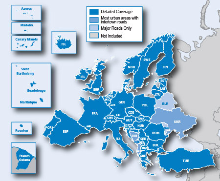
Abdeckung:
Hoster: Uploaded
200 MB Parts
Angegeben ist jeweils die gepackte Größe
Sprache: multi
-------------------------------------------------------------------------------------------------------------------------------------------------------------------------------------
Garmin City Navigator Europa NT 2016.20 gmap *UnLocked*
Format: gmap Unlocked
Size: 2,93 GB
-------------------------------------------------------------------------------------------------------------------------------------------------------------------------------------
Garmin City Navigator Europa NT 2016.20 - IMG Unlocked
Format: IMG Unlocked
Size: 2,64 GB
-------------------------------------------------------------------------------------------------------------------------------------------------------------------------------------
Garmin City Navigator Europa NT 2016.20 - 2GB Version IMG Unlocked
Central, West and South Europe
Format: IMG Unlocked
Size: 1,31 GB
Central, East and North Europe
Format: IMG Unlocked
Size: 1,41 GB
Für:
* nuvi 300 Series
* nuvi 600 Series
* nuvi 5000
* StreetPilot c500 Series
* OEM Zumo Series
* Garmin MobileXT
* Garmin MobilePC
* Kenwood
Und sonstige Garmin Geräte die nicht mit Karten zurechtkommen mit einer Größe von über 2GB
Genügend Speicherplatz vorausgesetzt kann man beide Karten auf eine SD packen und hat damit eine vollständige Europa-Karte
-------------------------------------------------------------------------------------------------------------------------------------------------------------------------------------
Garmin City Navigator D-A-CH NT 2016.20 - IMG Unlocked
Format: IMG Unlocked
Size: 374 MB
-------------------------------------------------------------------------------------------------------------------------------------------------------------------------------------
Hinweis IMG:
kopiere die enthaltene .IMG in den GARMIN-Ordner auf dem Gerät oder der SD-Karte.
Vorzugsweise ist sie auf der SD Karte zu installieren.
Ist kein Ordner Garmin vorhanden, diesen erstellen
-------------------------------------------------------------------------------------------------------------------------------------------------------------------------------------
JUNCTION VIEW - erweiterter Spurassistent
Pfad:
Neue Geräte mit verstecktem .System Ordner:
Device:\.System\JCV
Andere Geräte:
Device:\Garmin\JCV
Für alle Geräte wenn auf SD:
SD:\Garmin\JCV
( D3084170A ) 480x272 für Geräte mit Standard Auflösung
( D2504200A ) High Resolution für 7X5, ZUMO, 1XXX
3D-Gebäudeansichten
Kann genutzt werden mit Geräten die dieses Feature unterstützen:
Pfad:
Neue Geräte mit verstecktem .System Ordner
Device:\.System\gmap3d.img file
SD:\Map\gmap3d.img file
Andere Geräte
Device:\Garmin\gmap3d.img file
SD:\Garmin\gmap3d.img file
ASR"/Voice recognition files (Automatic Speech Recognition)
Pfad:
Neue Geräte mit verstecktem .System Ordner:
Device:\.System\ASR
Andere Geräte:
Device:\Garmin\ASR
Für alle Geräte wenn auf SD:
SD:\Garmin\ASR
G2S - Traffic Trends
Kann genutzt werden mit Geräten die dieses Feature unterstützen:
Pfad:
Neue Geräte mit verstecktem .System Ordner
Device:.System\SQLite\
SD:\Map\SQLite\
Andere Geräte
Device:\Garmin\SQLite\
SD:\Garmin\SQLite\
-------------------------------------------------------------------------------------------------------------------------------------------------------------------------------------
Garmin Speed-/Safety-cams 06.01.2016
Australia and New Zealand, Austria and Germany, Belgium and Luxembourg, Eastern Europe, Greece, Italy and Slovenia
Middle East, Netherlands, Nordics, Russia, South Africa, Spain and Portugal, U.K. and Ireland, U.S. and Canada, France
-
The Following 4 Users Say Thank You to Roadwarrior For This Useful Post:
- [ Click To Expand ]
-
benj620 (10th March 2016), costeld (16th November 2015), Darmmy (8th November 2015), Vitinesgonzalez (25th November 2015)
-
6th November 2015, 11:09 AM #3
Garmin City Navigator Europe NT 2016.20 ( UnLocked )
Map Source Data with .msi installer Unlocked (4.1GB)
Garmin City Navigator Polska NT 2016.20 - IMG Unlocked (170MB)
3D City Navigator Europe NT 2016.20 Unlocked (842MB)
Alps + DACH + G2S, JCV Full-Screen (810MB)
ASR-3790 (836MB)
Benelux & France (756MB)
Central & Eastern Europe Image+ G2S, JCV Full-Screen (2.2GB)
Central Region Image + G2S, JCV_Full-Screen (2.6GB)
Garmin City Navigator Europe NT 2016.20 Europe Image Unlocked (3.4GB)
Garmin City Navigator Europe NT 2016.20 Image Unlocked ( Selected areas )
Europe (1.42GB) (UnLocked)
Europe (752MB) (UnLocked)
DACH + CZ Unlocked (574MB)
City Navigator Europe NT 2016.20 G2S (435MB)
Germany Unlocked (369MB)
Iberia + G2S, JCV Full-Screen Unlocked (450MB)
Italia & Greece + G2S, JCV Full-Screen Unlocked (519MB)
JCV Full-Screen / LaneAssist Full (324MB)
Nordics + G2S, JCV Full-Screen Unlocked (424MB)
Northwest Eastern Europe Unlocked (491MB)
Turkey + G2S, JCV Full-Screen Unlocked (202MB)
UK & RoI + G2S, JCV Full-Screen Unlocked (469MB0
SQLite (159MB)
Western Europe + G2S, JCV Full-Screen Unlocked (2.9GB)
-
The Following 4 Users Say Thank You to studzina0812 For This Useful Post:
- [ Click To Expand ]
-
argh.nitrox (8th November 2015), estampi (22nd January 2016), ta1234 (30th November 2015), Vitinesgonzalez (25th November 2015)


 Register To Reply
Advertisements

Suggested Articles:


 Staff Online
iGO HERE EUROPE 2024.Q2
Hola, despues de descargar las dos partes, me...