


![BlueChart g2 - HAE006R - Timor Leste New Guinea 2014.5 [16.00]](https://www.hostdel.com/banners/Hosting/728x90.gif)
Results 1 to 3 of 3
-
15th January 2015, 04:35 AM #1
 Garmin Expert
Supporter

 BlueChart g2 - HAE006R - Timor Leste New Guinea 2014.5 [16.00]
BlueChart g2 - HAE006R - Timor Leste New Guinea 2014.5 (16.00)
See your vessels precise, on-chart position in relation to navaids, coastal features, anchorages, obstructions, waterways, restricted areas and more with this detailed marine mapping data.
- Shaded depth contours, coastlines, spot soundings, navaids, port plans, wrecks, obstructions, intertidal zones, restricted areas and IALA symbols.
- Seamless transitions between zoom levels and more continuity across chart boundaries.
- Standard 2-D direct overhead or 3-D over the bow map perspective for easy chart reading and orientation.
- Safety Shading* enables contour shading for all depth contours shallower than your defined safe depths.
- Fishing Charts* to scope out bottom contours and depth soundings with less visual clutter on the display.
- Plan and organize routes from your computer with HomePort (sold separately).
Coverage
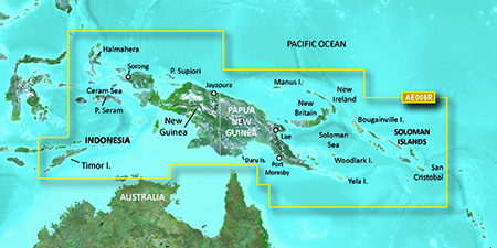
General coverage includes coasts of Timor Leste; the northernmost parts of Melville Island and the Cobourg Peninsula of Australia; Indonesia southeast and east of Sulawesi; Osprey Reef; all of Papua New Guinea and the Solomon Islands. Detailed coverage of Ambon, Indonesia; Snake Bay, Australia; Ternate, Indon, Lae, Rabaul, Karema and Port Moresby, P.N.G. and Honaira, S.I.
FID: 3494, PID: 1, RID: 3, VID: 6
Locked Image:
[SPOILER=Download File:-][/SPOILER]
UnLocked Image:
[SPOILER=Download File:-][/SPOILER]
 PiEtU Reviewed by PiEtU on . BlueChart g2 - HAE006R - Timor Leste New Guinea 2014.5 [16.00] BlueChart g2 - HAE006R - Timor Leste New Guinea 2014.5 (16.00) See your vessels precise, on-chart position in relation to navaids, coastal features, anchorages, obstructions, waterways, restricted areas and more with this detailed marine mapping data. Shaded depth contours, coastlines, spot soundings, navaids, port plans, wrecks, obstructions, intertidal zones, restricted areas and IALA symbols. Seamless transitions between zoom levels and more continuity across chart Rating: 5
-
25th March 2021, 06:34 PM #2

Re-uploaded this release
Enjoy.
-
16th April 2024, 12:47 PM #3
BlueChart g2 - HAE006R - Timor Leste New Guinea 2014.5 (16.00)
The address is invalid. Please provide a new download address. Thank you!
![BlueChart g2 - HAE006R - Timor Leste New Guinea 2014.5 [16.00]](https://www.hostdel.com/banners/RDP/300X250.gif)

 Register To Reply
Advertisements
![BlueChart g2 - HAE006R - Timor Leste New Guinea 2014.5 [16.00]](https://www.hostdel.com/banners/Dedicated/728x90.gif)
Suggested Articles:
![BlueChart g2 - HAE006R - Timor Leste New Guinea 2014.5 [16.00]](https://www.hostdel.com/banners/GameServer/728x90.gif)

![BlueChart g2 - HAE006R - Timor Leste New Guinea 2014.5 [16.00]](https://www.hostdel.com/banners/Email/300X250.gif)


 Staff Online
![BlueChart g2 - HAE006R - Timor Leste New Guinea 2014.5 [16.00]](https://www.hostdel.com/banners/Dedicated/300x600.gif)
Garmin Cyclops Safety Cameras -...
Garmin Cyclops Sept 20 AustraliaNewZealand...