


![BlueChart g2 - HEU712L - Sweden East & Gulf of Finland 2014.5 [16.00]](https://www.hostdel.com/banners/Hosting/728x90.gif)
Results 1 to 4 of 4
-
21st December 2014, 06:01 AM #1
 Garmin Expert
Supporter

 BlueChart g2 - HEU712L - Sweden East & Gulf of Finland 2014.5 [16.00]
BlueChart g2 - HEU712L - Sweden East & Gulf of Finland 2014.5 (16.00)
See your vessels precise, on-chart position in relation to navaids, coastal features, anchorages, obstructions, waterways, restricted areas and more with this detailed marine mapping data.
- Shaded depth contours, coastlines, spot soundings, navaids, port plans, wrecks, obstructions, intertidal zones, restricted areas and IALA symbols.
- Seamless transitions between zoom levels and more continuity across chart boundaries.
- Standard 2-D direct overhead or 3-D over the bow map perspective for easy chart reading and orientation.
- Safety Shading* enables contour shading for all depth contours shallower than your defined safe depths.
- Fishing Charts* to scope out bottom contours and depth soundings with less visual clutter on the display.
- Plan and organize routes from your computer with HomePort (sold separately).
Coverage
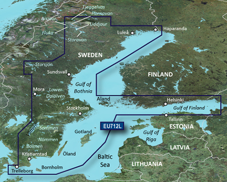
Detailed coverage of the coast of Sweden along the Baltic Sea and Gulf of Bothnia from Trelleborg to Haparanda including Kristianstad, Stockholm, Sundsvall, and Luleå; also coastal coverage of Finland's Gulf of Finland from Uusikaupunki to Vyborg, RU including Turku, Hanko, and Helsinki. Swedish lake coverage features Vättern, Sommen, Nommen, Revsundssjön, Hjälmaren, Siljan, Mälaren, Storsjön, Storavan, Uddjaur, Hornovan, Tjeggelvas, Aisjaur, Fluka, Helgasjön, and Bolmen, as well as coverage of the lower Dalälven from Gysinge to Söderfors. Island coverage features Bornholm, Oland, Gotland, and Åland.
FID: 3491, PID: 1, RID: 4, VID: 18
Locked Image:
UnLocked Image:
 PiEtU Reviewed by PiEtU on . BlueChart g2 - HEU712L - Sweden East & Gulf of Finland 2014.5 [16.00] BlueChart g2 - HEU712L - Sweden East & Gulf of Finland 2014.5 (16.00) See your vessels precise, on-chart position in relation to navaids, coastal features, anchorages, obstructions, waterways, restricted areas and more with this detailed marine mapping data. Shaded depth contours, coastlines, spot soundings, navaids, port plans, wrecks, obstructions, intertidal zones, restricted areas and IALA symbols. Seamless transitions between zoom levels and more continuity across chart Rating: 5
-
8th March 2020, 05:01 PM #2
*edit
dubble post, sorry.
-
8th March 2020, 05:02 PM #3
Please upload again, the download links are down..
-
The Following 1 Users Say Thank You to Jonis For This Useful Post:
- [ Click To Expand ]
-
Kirsche81 (26th June 2020)
-
25th March 2021, 02:32 AM #4

Re-uploaded this release
Enjoy.
![BlueChart g2 - HEU712L - Sweden East & Gulf of Finland 2014.5 [16.00]](https://www.hostdel.com/banners/RDP/300X250.gif)

 Register To Reply
Advertisements
![BlueChart g2 - HEU712L - Sweden East & Gulf of Finland 2014.5 [16.00]](https://www.hostdel.com/banners/Dedicated/728x90.gif)
Suggested Articles:
![BlueChart g2 - HEU712L - Sweden East & Gulf of Finland 2014.5 [16.00]](https://www.hostdel.com/banners/GameServer/728x90.gif)

![BlueChart g2 - HEU712L - Sweden East & Gulf of Finland 2014.5 [16.00]](https://www.hostdel.com/banners/Email/300X250.gif)


 Staff Online
![BlueChart g2 - HEU712L - Sweden East & Gulf of Finland 2014.5 [16.00]](https://www.hostdel.com/banners/Dedicated/300x600.gif)
City Navigator Europe NT 2025.10...
New map requires 14 GB......... with GE & the...