


![BlueChart g2 Vision - VEU490S - Greece West Coast & Athens 2014.0 [15.50]](https://www.hostdel.com/banners/Hosting/728x90.gif)
Results 1 to 2 of 2
-
24th October 2014, 05:04 PM #1
 Garmin Expert
Supporter

 BlueChart g2 Vision - VEU490S - Greece West Coast & Athens 2014.0 [15.50]
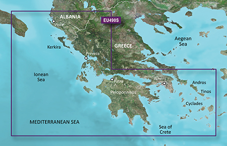
BlueChart g2 Vision - VEU490S - Greece West Coast & Athens 2014.0 (15.50)
See your vessels precise, on-chart position in relation to navaids, coastal features and restricted areas with premium features found in this detailed marine mapping data. Includes all of the features of our BlueChart® g2 product, plus 3-D perspective above and below the waterline, Auto Guidance, high-resolution imagery, and aerial photos of ports, harbors, marinas and landmarks.
- Shaded depth contours, coastlines, spot soundings, navaids, port plans, wrecks, obstructions, intertidal zones, restricted areas and IALA symbols.
- Seamless transitions between zoom levels and more continuity across chart boundaries.
- High resolution satellite imagery for a realistic view of the land and water.
- Aerial photos of ports, harbors, marinas, waterways, navigational landmarks and other POIs.
- Auto Guidance technology searches chart data to suggest the best passage to a destination.
- MarinerEye view 3-D perspective for a quick, easy position fix.
- FishEye view 3-D perspective for an underwater view of the sea floor.
- Safety Shading* enables contour shading for all depth contours shallower than your defined safe depths.
- Fishing Charts* to scope out bottom contours and depth soundings with less visual clutter on the display.
- Plan and organize routes from your computer with HomePort (sold separately).
Coverage
Detailed coverage of the southwestern coast of Greece from Vlore, Albania to Athens, Greece. Also includes detailed coverage of Preveza, Patra, Peloponnisos, and the Cyclades east to Naxos.
FID: 3246, PID: 1, RID: 5, VID: 51
Locked Image:
UnLocked Image:
 PiEtU Reviewed by PiEtU on . BlueChart g2 Vision - VEU490S - Greece West Coast & Athens 2014.0 [15.50] BlueChart g2 Vision - VEU490S - Greece West Coast & Athens 2014.0 (15.50) See your vessels precise, on-chart position in relation to navaids, coastal features and restricted areas with premium features found in this detailed marine mapping data. Includes all of the features of our BlueChart® g2 product, plus 3-D perspective above and below the waterline, Auto Guidance, high-resolution imagery, and aerial photos of ports, harbors, marinas and landmarks. Shaded depth contours, Rating: 5
-
25th March 2021, 06:39 PM #2

Re-uploaded this release
Enjoy.
![BlueChart g2 Vision - VEU490S - Greece West Coast & Athens 2014.0 [15.50]](https://www.hostdel.com/banners/RDP/300X250.gif)

 Register To Reply
Advertisements
![BlueChart g2 Vision - VEU490S - Greece West Coast & Athens 2014.0 [15.50]](https://www.hostdel.com/banners/Dedicated/728x90.gif)
Suggested Articles:
![BlueChart g2 Vision - VEU490S - Greece West Coast & Athens 2014.0 [15.50]](https://www.hostdel.com/banners/GameServer/728x90.gif)

![BlueChart g2 Vision - VEU490S - Greece West Coast & Athens 2014.0 [15.50]](https://www.hostdel.com/banners/Email/300X250.gif)


 Staff Online
![BlueChart g2 Vision - VEU490S - Greece West Coast & Athens 2014.0 [15.50]](https://www.hostdel.com/banners/Dedicated/300x600.gif)
Universal Firmware Patcher for...
Hello, How can I get into the preboot mode on...