


![BlueChart g2 - HEU454S - Barcelona & Valencia 2014.0 [15.50]](https://www.hostdel.com/banners/Hosting/728x90.gif)
Results 1 to 3 of 3
-
11th October 2014, 03:33 PM #1
 Garmin Expert
Supporter

 BlueChart g2 - HEU454S - Barcelona & Valencia 2014.0 [15.50]
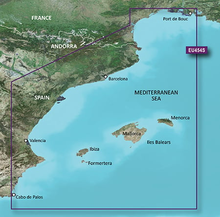
BlueChart g2 - HEU454S - Barcelona & Valencia 2014.0 (15.50)
See your vessels precise, on-chart position in relation to navaids, coastal features, anchorages, obstructions, waterways, restricted areas and more with this detailed marine mapping data.
- Shaded depth contours, coastlines, spot soundings, navaids, port plans, wrecks, obstructions, intertidal zones, restricted areas and IALA symbols.
- Seamless transitions between zoom levels and more continuity across chart boundaries.
- Standard 2-D direct overhead or 3-D over the bow map perspective for easy chart reading and orientation.
- Safety Shading* enables contour shading for all depth contours shallower than your defined safe depths.
- Fishing Charts* to scope out bottom contours and depth soundings with less visual clutter on the display.
- Plan and organize routes from your computer with HomePort (sold separately).
Coverage
From Port de Bouc, France to Cabo de Palos, Spain, including Islas Baleares.
FID: 3255, PID: 1, RID: 5, VID: 5
Locked Image:
UnLocked Image:
 PiEtU Reviewed by PiEtU on . BlueChart g2 - HEU454S - Barcelona & Valencia 2014.0 [15.50] BlueChart g2 - HEU454S - Barcelona & Valencia 2014.0 (15.50) See your vessels precise, on-chart position in relation to navaids, coastal features, anchorages, obstructions, waterways, restricted areas and more with this detailed marine mapping data. Shaded depth contours, coastlines, spot soundings, navaids, port plans, wrecks, obstructions, intertidal zones, restricted areas and IALA symbols. Seamless transitions between zoom levels and more continuity across chart boundaries. Rating: 5
-
25th March 2021, 06:52 PM #2

Re-uploaded this release
Enjoy.
-
The Following 1 Users Say Thank You to dennisolof For This Useful Post:
- [ Click To Expand ]
-
tomojure (25th March 2021)
-
11th January 2024, 11:17 PM #3
can you reupload please??
![BlueChart g2 - HEU454S - Barcelona & Valencia 2014.0 [15.50]](https://www.hostdel.com/banners/RDP/300X250.gif)

 Register To Reply
Advertisements
![BlueChart g2 - HEU454S - Barcelona & Valencia 2014.0 [15.50]](https://www.hostdel.com/banners/Dedicated/728x90.gif)
Suggested Articles:
![BlueChart g2 - HEU454S - Barcelona & Valencia 2014.0 [15.50]](https://www.hostdel.com/banners/GameServer/728x90.gif)

![BlueChart g2 - HEU454S - Barcelona & Valencia 2014.0 [15.50]](https://www.hostdel.com/banners/Email/300X250.gif)


 Staff Online
![BlueChart g2 - HEU454S - Barcelona & Valencia 2014.0 [15.50]](https://www.hostdel.com/banners/Dedicated/300x600.gif)
Garmin City Navigator Europe NTU...
Welcome to the forum. Your device uses these NTU...