


![BlueChart g2 Vision - VEU004R - Irish Sea 2014.0 [15.50]](https://www.hostdel.com/banners/Hosting/728x90.gif)
Results 1 to 4 of 4
-
25th July 2014, 05:33 AM #1
 Garmin Expert
Supporter

 BlueChart g2 Vision - VEU004R - Irish Sea 2014.0 [15.50]
BlueChart g2 Vision - VEU004R - Irish Sea 2014.0 (15.50)
See your vessels precise, on-chart position in relation to navaids, coastal features and restricted areas with premium features found in this detailed marine mapping data. Includes all of the features of our BlueChart® g2 product, plus 3-D perspective above and below the waterline, Auto Guidance, high-resolution imagery, and aerial photos of ports, harbors, marinas and landmarks.
- Shaded depth contours, coastlines, spot soundings, navaids, port plans, wrecks, obstructions, intertidal zones, restricted areas and IALA symbols.
- Seamless transitions between zoom levels and more continuity across chart boundaries.
- High resolution satellite imagery for a realistic view of the land and water.
- Aerial photos of ports, harbors, marinas, waterways, navigational landmarks and other POIs.
- Auto Guidance technology searches chart data to suggest the best passage to a destination.
- MarinerEye view 3-D perspective for a quick, easy position fix.
- FishEye view 3-D perspective for an underwater view of the sea floor.
- Safety Shading* enables contour shading for all depth contours shallower than your defined safe depths.
- Fishing Charts* to scope out bottom contours and depth soundings with less visual clutter on the display.
- Plan and organize routes from your computer with HomePort (sold separately).
Coverage
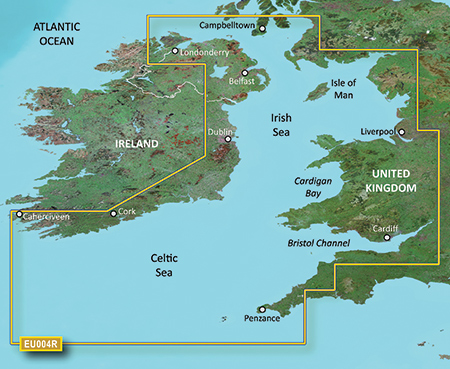
British coast: covers from Port Ellen on the Isle of Islay to Falmouth, including the Isle of Man and the Isles of Scilly. Irish coast: covers from Sheep Haven to Caherciveen, Republic of Ireland, including Londonderry, The Storks, Belfast, and Dublin.
FID: 3247, PID: 1, RID: 2, VID: 11
Locked Image:
UnLocked Image:
 PiEtU Reviewed by PiEtU on . BlueChart g2 Vision - VEU004R - Irish Sea 2014.0 [15.50] BlueChart g2 Vision - VEU004R - Irish Sea 2014.0 (15.50) See your vessels precise, on-chart position in relation to navaids, coastal features and restricted areas with premium features found in this detailed marine mapping data. Includes all of the features of our BlueChart® g2 product, plus 3-D perspective above and below the waterline, Auto Guidance, high-resolution imagery, and aerial photos of ports, harbors, marinas and landmarks. Shaded depth contours, coastlines, spot Rating: 5
-
16th November 2016, 02:05 AM #2
Hello kind sir. Can you please repost a mirror of this map? The link appears to be expired

-
The Following 1 Users Say Thank You to vantec For This Useful Post:
- [ Click To Expand ]
-
pcondes (17th June 2019)
-
17th June 2019, 08:30 AM #3
-
25th March 2021, 02:26 AM #4

Re-uploaded this release
Enjoy.
![BlueChart g2 Vision - VEU004R - Irish Sea 2014.0 [15.50]](https://www.hostdel.com/banners/RDP/300X250.gif)

 Register To Reply
Advertisements
![BlueChart g2 Vision - VEU004R - Irish Sea 2014.0 [15.50]](https://www.hostdel.com/banners/Dedicated/728x90.gif)
Suggested Articles:
![BlueChart g2 Vision - VEU004R - Irish Sea 2014.0 [15.50]](https://www.hostdel.com/banners/GameServer/728x90.gif)

![BlueChart g2 Vision - VEU004R - Irish Sea 2014.0 [15.50]](https://www.hostdel.com/banners/Email/300X250.gif)


 Staff Online
![BlueChart g2 Vision - VEU004R - Irish Sea 2014.0 [15.50]](https://www.hostdel.com/banners/Dedicated/300x600.gif)
World/Europe Speedcams from SCDB
But this is a new invention of thieves. To steal,...