


![BlueChart g2 Vision - VUS031R - Southwest Caribbean 2014.0 [15.50]](https://www.hostdel.com/banners/Hosting/728x90.gif)
Results 1 to 6 of 6
-
22nd July 2014, 04:29 AM #1
 Garmin Expert
Supporter

 BlueChart g2 Vision - VUS031R - Southwest Caribbean 2014.0 [15.50]
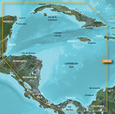
BlueChart g2 Vision - VUS031R - Southwest Caribbean 2014.0 (15.50)
See your vessel’s precise, on-chart position in relation to navaids, coastal features and restricted areas with premium features found in this detailed marine mapping data. Includes all of the features of our BlueChart® g2 product, plus 3-D perspective above and below the waterline, Auto Guidance, high-resolution imagery, and aerial photos of ports, harbors, marinas and landmarks.
- Shaded depth contours, coastlines, spot soundings, navaids, port plans, wrecks, obstructions, intertidal zones, restricted areas and IALA symbols.
- Seamless transitions between zoom levels and more continuity across chart boundaries.
- High resolution satellite imagery for a realistic view of the land and water.
- Aerial photos of ports, harbors, marinas, waterways, navigational landmarks and other POIs.
- Auto Guidance technology searches chart data to suggest the best passage to a destination.
- MarinerEye view 3-D perspective for a quick, easy position fix.
- FishEye view 3-D perspective for an underwater view of the sea floor.
- Safety Shading* enables contour shading for all depth contours shallower than your defined safe depths.
- Fishing Charts* to scope out bottom contours and depth soundings with less visual clutter on the display.
- Plan and organize routes from your computer with HomePort™ (sold separately).
Coverage
Detailed coverage of the northern coast of Central America from Cancun, Mexico to Barranquilla, Colombia, including the Panama Canal in its entirety. General coverage of the northern half of the Gulf of Panama. Also includes detailed coverage of the coasts of Cuba, Jamaica, and the Caymans in their entirety.
FID: 3244, PID: 1, RID: 1, VID: 42
Locked Image:
UnLocked Image:
 PiEtU Reviewed by PiEtU on . BlueChart g2 Vision - VUS031R - Southwest Caribbean 2014.0 [15.50] BlueChart g2 Vision - VUS031R - Southwest Caribbean 2014.0 (15.50) See your vessel’s precise, on-chart position in relation to navaids, coastal features and restricted areas with premium features found in this detailed marine mapping data. Includes all of the features of our BlueChart® g2 product, plus 3-D perspective above and below the waterline, Auto Guidance, high-resolution imagery, and aerial photos of ports, harbors, marinas and landmarks. Shaded depth contours, coastlines, spot Rating: 5
-
The Following 3 Users Say Thank You to PiEtU For This Useful Post:
- [ Click To Expand ]
-
-
27th September 2015, 12:34 AM #2
hi
Links are Dead, is it possible to have new ? Thak you very much by advance
-
The Following 1 Users Say Thank You to H4XX971 For This Useful Post:
- [ Click To Expand ]
-
Toros (15th August 2019)
-
5th December 2019, 08:52 AM #3
Hello,
The link dont work, it's possible to have a way to have a new please ? thanks yalll !!
-
22nd March 2021, 08:51 PM #4

Re-uploaded this release
Enjoy.
-
13th March 2023, 11:36 PM #5
broken links if someone can reupload it thanks
enlaces caidos si alguien lo puede resubir graciasLast edited by Garmin_Nuvi; 14th March 2023 at 02:20 AM. Reason: Translate 1st & last time
-
21st April 2023, 09:59 PM #6
good day
Could you upload the map again?
![BlueChart g2 Vision - VUS031R - Southwest Caribbean 2014.0 [15.50]](https://www.hostdel.com/banners/RDP/300X250.gif)

 Register To Reply
Advertisements
![BlueChart g2 Vision - VUS031R - Southwest Caribbean 2014.0 [15.50]](https://www.hostdel.com/banners/Dedicated/728x90.gif)
Suggested Articles:
![BlueChart g2 Vision - VUS031R - Southwest Caribbean 2014.0 [15.50]](https://www.hostdel.com/banners/GameServer/728x90.gif)

![BlueChart g2 Vision - VUS031R - Southwest Caribbean 2014.0 [15.50]](https://www.hostdel.com/banners/Email/300X250.gif)


 Staff Online
![BlueChart g2 Vision - VUS031R - Southwest Caribbean 2014.0 [15.50]](https://www.hostdel.com/banners/Dedicated/300x600.gif)
Garmin Cyclops Safety Cameras -...
Garmin Cyclops Sept 20 AustraliaNewZealand...