


![BlueChart g2 - HEU505S - Baltic Sea, East Coast 2014.0 [15.50]](https://www.hostdel.com/banners/Hosting/728x90.gif)
Results 1 to 3 of 3
-
6th May 2014, 03:18 PM #1
 Garmin Expert
Supporter

 BlueChart g2 - HEU505S - Baltic Sea, East Coast 2014.0 [15.50]
BlueChart g2 - HEU505S - Baltic Sea, East Coast 2014.0 (15.50)
See your vessels precise, on-chart position in relation to navaids, coastal features, anchorages, obstructions, waterways, restricted areas and more with this detailed marine mapping data.
- Shaded depth contours, coastlines, spot soundings, navaids, port plans, wrecks, obstructions, intertidal zones, restricted areas and IALA symbols.
- Seamless transitions between zoom levels and more continuity across chart boundaries.
- Standard 2-D direct overhead or 3-D over the bow map perspective for easy chart reading and orientation.
- Safety Shading* enables contour shading for all depth contours shallower than your defined safe depths.
- Fishing Charts* to scope out bottom contours and depth soundings with less visual clutter on the display.
- Plan and organize routes from your computer with HomePort (sold separately).
Coverage
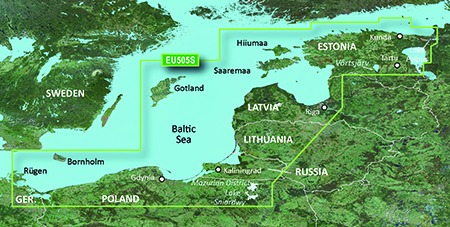
Coverage of the coasts of Germany, Poland, Russia, Lithuania, Latvia and Estonia from Rügen, DE to Narva-Jõesuu, EE. Detailed coverage includes the Szczecin Lagoon, Bornholm, the Vistula Lagoon, Kaliningrad, Gotland, the Gulf of Riga, Saaremaa, Hiiumaa, Lake Peipus, and the Mazurian and other Polish lakes including Lake Jeziorak, Lake Lanskie and Lake Sniardwy.
FID: 3255, PID: 1, RID: 5, VID: 16
Locked Image:
UnLocked Image:
 PiEtU Reviewed by PiEtU on . BlueChart g2 - HEU505S - Baltic Sea, East Coast 2014.0 [15.50] BlueChart g2 - HEU505S - Baltic Sea, East Coast 2014.0 (15.50) See your vessels precise, on-chart position in relation to navaids, coastal features, anchorages, obstructions, waterways, restricted areas and more with this detailed marine mapping data. Shaded depth contours, coastlines, spot soundings, navaids, port plans, wrecks, obstructions, intertidal zones, restricted areas and IALA symbols. Seamless transitions between zoom levels and more continuity across chart Rating: 5
-
11th June 2020, 03:18 PM #2
Please reupload links
-
25th March 2021, 02:37 AM #3

Re-uploaded this release
Enjoy.
-
The Following 1 Users Say Thank You to dennisolof For This Useful Post:
- [ Click To Expand ]
-
ta1234 (19th June 2021)
![BlueChart g2 - HEU505S - Baltic Sea, East Coast 2014.0 [15.50]](https://www.hostdel.com/banners/RDP/300X250.gif)

 Register To Reply
Advertisements
![BlueChart g2 - HEU505S - Baltic Sea, East Coast 2014.0 [15.50]](https://www.hostdel.com/banners/Dedicated/728x90.gif)
Suggested Articles:
![BlueChart g2 - HEU505S - Baltic Sea, East Coast 2014.0 [15.50]](https://www.hostdel.com/banners/GameServer/728x90.gif)
Similar Threads
-
BlueChart g2 Vision - VUS009R - Jacksonville-Key West 2014 [15.50]
By PiEtU in forum Garmin MapsReplies: 4Last Post: 12th April 2023, 11:08 PM -
BlueChart g2 - HSA001R - South America East Coast 2014.0 [15.50]
By PiEtU in forum Garmin MapsReplies: 5Last Post: 4th May 2022, 10:15 PM -
BlueChart g2 - HEU452S - Adriatic Sea, North Coast 2014.0 [15.50]
By PiEtU in forum Garmin ArchivesReplies: 2Last Post: 25th March 2021, 02:38 AM -
BlueChart g2 - HEU505S - Baltic Sea, East Coast 2014.0 [15.50]
By PiEtU in forum Garmin MapsReplies: 0Last Post: 6th May 2014, 03:18 PM -
BlueChart g2 - HEU452S - Adriatic Sea, North Coast 2014.0 [15.50]
By PiEtU in forum Garmin MapsReplies: 0Last Post: 6th May 2014, 02:06 AM

![BlueChart g2 - HEU505S - Baltic Sea, East Coast 2014.0 [15.50]](https://www.hostdel.com/banners/Email/300X250.gif)


 Staff Online
![BlueChart g2 - HEU505S - Baltic Sea, East Coast 2014.0 [15.50]](https://www.hostdel.com/banners/Dedicated/300x600.gif)
Universal Firmware Patcher for...
Hello, How can I get into the preboot mode on...