


![BlueChart g2 Vision - VEU043R - Iceland & Faeroe Islands 2014.0 [15.50]](https://www.hostdel.com/banners/Hosting/728x90.gif)
Results 1 to 2 of 2
-
28th April 2014, 04:22 PM #1
 Garmin Expert
Supporter

 BlueChart g2 Vision - VEU043R - Iceland & Faeroe Islands 2014.0 [15.50]
BlueChart g2 Vision - VEU043R - Iceland & Faeroe Islands 2014.0 (15.50)
See your vessel’s precise, on-chart position in relation to navaids, coastal features and restricted areas with premium features found in this detailed marine mapping data. Includes all of the features of our BlueChart® g2 product, plus 3-D perspective above and below the waterline, Auto Guidance, high-resolution imagery, and aerial photos of ports, harbors, marinas and landmarks.
- Shaded depth contours, coastlines, spot soundings, navaids, port plans, wrecks, obstructions, intertidal zones, restricted areas and IALA symbols.
- Seamless transitions between zoom levels and more continuity across chart boundaries.
- High resolution satellite imagery for a realistic view of the land and water.
- Aerial photos of ports, harbors, marinas, waterways, navigational landmarks and other POIs.
- Auto Guidance technology searches chart data to suggest the best passage to a destination.
- MarinerEye view 3-D perspective for a quick, easy position fix.
- FishEye view 3-D perspective for an underwater view of the sea floor.
- Safety Shading* enables contour shading for all depth contours shallower than your defined safe depths.
- Fishing Charts* to scope out bottom contours and depth soundings with less visual clutter on the display.
- Plan and organize routes from your computer with HomePort™ (sold separately).
Coverage
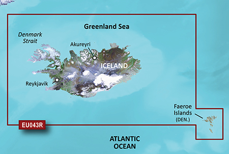
Includes detailed coverage of all of Iceland including the cities of Reykjavik and Akureyri. Also includes detailed coverage of the Faeroe Islands including Stromo, Ostero, Sydero and Bordo Islands.
FID: 3247, PID: 1, RID: 2, VID: 46
Locked Image:
UnLocked Image:
 PiEtU Reviewed by PiEtU on . BlueChart g2 Vision - VEU043R - Iceland & Faeroe Islands 2014.0 [15.50] BlueChart g2 Vision - VEU043R - Iceland & Faeroe Islands 2014.0 (15.50) See your vessel’s precise, on-chart position in relation to navaids, coastal features and restricted areas with premium features found in this detailed marine mapping data. Includes all of the features of our BlueChart® g2 product, plus 3-D perspective above and below the waterline, Auto Guidance, high-resolution imagery, and aerial photos of ports, harbors, marinas and landmarks. Shaded depth contours, coastlines, Rating: 5
-
The Following 1 Users Say Thank You to PiEtU For This Useful Post:
- [ Click To Expand ]
-
ta1234 (18th June 2021)
-
25th March 2021, 10:04 PM #2

Re-uploaded this release
Enjoy.
-
The Following 2 Users Say Thank You to dennisolof For This Useful Post:
- [ Click To Expand ]
-
![BlueChart g2 Vision - VEU043R - Iceland & Faeroe Islands 2014.0 [15.50]](https://www.hostdel.com/banners/RDP/300X250.gif)

 Register To Reply
Advertisements
![BlueChart g2 Vision - VEU043R - Iceland & Faeroe Islands 2014.0 [15.50]](https://www.hostdel.com/banners/Dedicated/728x90.gif)
Suggested Articles:
![BlueChart g2 Vision - VEU043R - Iceland & Faeroe Islands 2014.0 [15.50]](https://www.hostdel.com/banners/GameServer/728x90.gif)
Similar Threads
-
BlueChart g2 Vision - VEU706L - UK-Ireland-The Netherlands 2014.0 [15.50]
By p33dro in forum Garmin MapsReplies: 12Last Post: 28th August 2021, 06:01 PM -
BlueChart g2 Vision - VEU717L - East Mediterranean & Black Sea 2014.0 [15.50]
By p33dro in forum Garmin MapsReplies: 4Last Post: 28th March 2021, 05:31 AM -
BlueChart g2 Vision - VEU043R - Iceland & Faeroe Islands 2014.0 [15.50]
By PiEtU in forum Garmin MapsReplies: 0Last Post: 28th April 2014, 04:22 PM

![BlueChart g2 Vision - VEU043R - Iceland & Faeroe Islands 2014.0 [15.50]](https://www.hostdel.com/banners/Email/300X250.gif)


 Staff Online
![BlueChart g2 Vision - VEU043R - Iceland & Faeroe Islands 2014.0 [15.50]](https://www.hostdel.com/banners/Dedicated/300x600.gif)
City Navigator North America NT...
thank you, I will patiently wait for 3d map for...