


![BlueChart g2 Vision - VPC022R - East Coast Australia 2014.0 [15.50]](https://www.hostdel.com/banners/Hosting/728x90.gif)
Results 1 to 10 of 11
-
29th March 2014, 04:41 AM #1
 Garmin Master

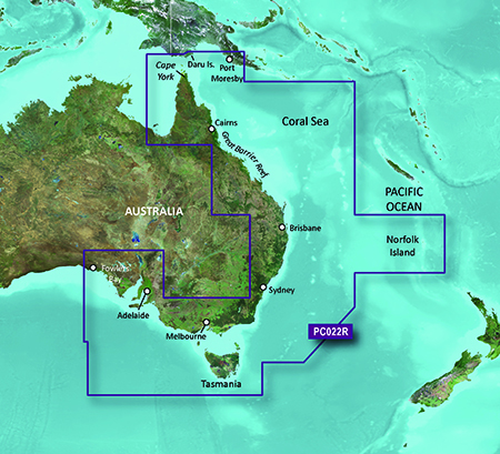
 BlueChart g2 Vision - VPC022R - East Coast Australia 2014.0 [15.50]
BlueChart g2 Vision - VPC022R - East Coast Australia 2014.0 (15.50)
See your vessels precise, on-chart position in relation to navaids, coastal features and restricted areas with premium features found in this detailed marine mapping data. Includes all of the features of our BlueChart® g2 product, plus 3-D perspective above and below the waterline, Auto Guidance, high-resolution imagery, and aerial photos of ports, harbors, marinas and landmarks.
- Shaded depth contours, coastlines, spot soundings, navaids, port plans, wrecks, obstructions, intertidal zones, restricted areas and IALA symbols.
- Seamless transitions between zoom levels and more continuity across chart boundaries.
- High resolution satellite imagery for a realistic view of the land and water.
- Aerial photos of ports, harbors, marinas, waterways, navigational landmarks and other POIs.
- Auto Guidance technology searches chart data to suggest the best passage to a destination.
- MarinerEye view 3-D perspective for a quick, easy position fix.
- FishEye view 3-D perspective for an underwater view of the sea floor.
- Safety Shading* enables contour shading for all depth contours shallower than your defined safe depths.
- Fishing Charts* to scope out bottom contours and depth soundings with less visual clutter on the display.
- Plan and organize routes from your computer with HomePort (sold separately).
Coverage
Detailed coverage of the Eastern coast of Australia from Mornington Island to Fowlers Bay. Also includes detailed coverage of Cape York, the Great Barrier Reef, Brisbane, Sydney, Melbourne, Adelaide, Tasmania, and Norfolk Island.
FID: 3250, PID: 1, RID: 3, VID: 33
Locked Image:
UnLocked Image:
 p33dro Reviewed by p33dro on . BlueChart g2 Vision - VPC022R - East Coast Australia 2014.0 [15.50] BlueChart g2 Vision - VPC022R - East Coast Australia 2014.0 (15.50) See your vessels precise, on-chart position in relation to navaids, coastal features and restricted areas with premium features found in this detailed marine mapping data. Includes all of the features of our BlueChart® g2 product, plus 3-D perspective above and below the waterline, Auto Guidance, high-resolution imagery, and aerial photos of ports, harbors, marinas and landmarks. Shaded depth contours, coastlines, Rating: 5When nothing goes right, go left.
-
The Following 1 Users Say Thank You to p33dro For This Useful Post:
- [ Click To Expand ]
-
Yannis (14th September 2018)
-
3rd April 2016, 06:01 AM #2
Dead link for unlocked files
-
24th February 2019, 04:46 PM #3
Anyone got working links?
Sent from my SM-G935F using Tapatalk
-
29th May 2019, 04:50 PM #4

Re-uploaded this release
Enjoy.Last edited by dennisolof; 25th March 2021 at 02:21 AM.
-
The Following 2 Users Say Thank You to dennisolof For This Useful Post:
- [ Click To Expand ]
-
coolblue (30th April 2023), madscientist86 (29th May 2019)
-
29th May 2019, 04:54 PM #5
-
The Following 1 Users Say Thank You to madscientist86 For This Useful Post:
- [ Click To Expand ]
-
coolblue (30th April 2023)
-
29th May 2019, 05:41 PM #6
Ok, well now you have my copy as well. I collected as many Garmin G2 BlueChart and Vision maps as I could, this was on other forums back when they where posting them like crazy. But the last four years it died out, and the other forums shut down. This is the only one left I know of where you can post maps and they do post updates to maps.
-
The Following 2 Users Say Thank You to dennisolof For This Useful Post:
- [ Click To Expand ]
-
coolblue (30th April 2023), madscientist86 (29th May 2019)
-
15th November 2023, 09:09 AM #7
 GPSMAP 78 and Bluechart Australia
Hi all,
I am trying to get an unlocked Bluechart for Eastern Australia onto my GPSMAP 78.
I have been reading through a bunch of the interesting tutorials on this forum, but most seem to involve getting an existing map file to work with Mapsource/Basecamp. Where would I begin looking for the right Bluechart file?
Any general pointers would be appreciated!
-
16th November 2023, 02:43 AM #8
 Garmin Mod
Supporter
![BlueChart g2 Vision - VPC022R - East Coast Australia 2014.0 [15.50]](http://www.gpsurl.com/images/ranks/moderator.png)
Last edited by Garmin_Nuvi; 16th November 2023 at 05:54 AM.
Unless you are a "New" member, having used the Thanks button regularly is the quickest way to get help.
-
The Following 1 Users Say Thank You to Garmin_Nuvi For This Useful Post:
- [ Click To Expand ]
-
del2775 (16th November 2023)
-
16th November 2023, 05:06 AM #9
yes, it seems like all of the uploaded files are from many years ago and no longer work.
There is a legit-looking SD card with unlocked files on ebay for $40 as a last resort I suppose
-
16th November 2023, 06:01 AM #10
Garmin Mod
Supporter
I've uploaded on a random file sharing platform so download before they vanish Your files will be stored for 7 days, the problem is these BlueCharts are difficult to make work on the latest Chart plotters so not requested much and those that share use up their storage space on files that are only downloaded every 3-4 years.
Buy $40 worth of beer for your crew instead
Last edited by Garmin_Nuvi; 16th November 2023 at 06:13 AM.
Unless you are a "New" member, having used the Thanks button regularly is the quickest way to get help.
-
The Following 1 Users Say Thank You to Garmin_Nuvi For This Useful Post:
- [ Click To Expand ]
-
del2775 (16th November 2023)
![BlueChart g2 Vision - VPC022R - East Coast Australia 2014.0 [15.50]](https://www.hostdel.com/banners/RDP/300X250.gif)

 Register To Reply
Advertisements
![BlueChart g2 Vision - VPC022R - East Coast Australia 2014.0 [15.50]](https://www.hostdel.com/banners/Dedicated/728x90.gif)
Suggested Articles:
![BlueChart g2 Vision - VPC022R - East Coast Australia 2014.0 [15.50]](https://www.hostdel.com/banners/GameServer/728x90.gif)
Similar Threads
-
BlueChart g2 Vision - VUS009R - Jacksonville-Key West 2014 [15.50]
By PiEtU in forum Garmin MapsReplies: 4Last Post: 12th April 2023, 11:08 PM -
BlueChart g2 Vision - VEU717L - East Mediterranean & Black Sea 2014.0 [15.50]
By p33dro in forum Garmin MapsReplies: 4Last Post: 28th March 2021, 05:31 AM -
BlueChart g2 Vision - VPC022R - East Coast Australia 2014.0 [15.50]
By p33dro in forum Garmin MapsReplies: 1Last Post: 3rd April 2016, 06:01 AM -
BlueChart g2 Vision - VPC022R - East Coast Australia
By p33dro in forum Garmin ArchivesReplies: 0Last Post: 16th December 2012, 07:05 AM -
BlueChart g2 Vision - VPC022R - East Coast Australia
By p33dro in forum Garmin MapsReplies: 0Last Post: 16th December 2012, 07:05 AM

![BlueChart g2 Vision - VPC022R - East Coast Australia 2014.0 [15.50]](https://www.hostdel.com/banners/Email/300X250.gif)


 Staff Online
![BlueChart g2 Vision - VPC022R - East Coast Australia 2014.0 [15.50]](https://www.hostdel.com/banners/Dedicated/300x600.gif)
City Navigator Europe NT 2025.10...
I would get a 32GB SD card they are only a few...