


![BlueChart g2 - HPC024R - Australia & New Zealand 2014.0 [15.50]](https://www.hostdel.com/banners/Hosting/728x90.gif)
Results 1 to 3 of 3
-
29th March 2014, 03:56 AM #1
 Garmin Master

 BlueChart g2 - HPC024R - Australia & New Zealand 2014.0 [15.50]
BlueChart g2 - HPC024R - Australia & New Zealand 2014.0 (15.50)
See your vessels precise, on-chart position in relation to navaids, coastal features, anchorages, obstructions, waterways, restricted areas and more with this detailed marine mapping data.
- Shaded depth contours, coastlines, spot soundings, navaids, port plans, wrecks, obstructions, intertidal zones, restricted areas and IALA symbols.
- Seamless transitions between zoom levels and more continuity across chart boundaries.
- Standard 2-D direct overhead or 3-D over the bow map perspective for easy chart reading and orientation.
- Safety Shading* enables contour shading for all depth contours shallower than your defined safe depths.
- Fishing Charts* to scope out bottom contours and depth soundings with less visual clutter on the display.
- Plan and organize routes from your computer with HomePort (sold separately).
Coverage
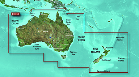
Detailed coverage of the entire continent of Australia and New Zealand. Coverage includes Brisbane, Sydney, and the Great Barrier Reef along the Eastern coast. Coverage continues along the Southern coast including Melbourne, Adelaide, and Tasmania through the Great Australian Bight. Coverage also includes Perth, Geraldton, Darwin, and the Gulf of Carpentaria on the Western and Northern coasts. Detailed coverage of New Zealand, including the North and South Islands in their entirety, as well as Norfolk Island, Auckland Islands, Campbell Island, Antipodes Islands, and Bounty Islands.
FID: 3260, PID: 1, RID: 3, VID: 35
Locked Image:
UnLocked Image:
 p33dro Reviewed by p33dro on . BlueChart g2 - HPC024R - Australia & New Zealand 2014.0 [15.50] BlueChart g2 - HPC024R - Australia & New Zealand 2014.0 (15.50) See your vessels precise, on-chart position in relation to navaids, coastal features, anchorages, obstructions, waterways, restricted areas and more with this detailed marine mapping data. Shaded depth contours, coastlines, spot soundings, navaids, port plans, wrecks, obstructions, intertidal zones, restricted areas and IALA symbols. Seamless transitions between zoom levels and more continuity across chart Rating: 5When nothing goes right, go left.
-
3rd January 2016, 06:31 AM #2
Links dead
Any chance of new links please
-
25th March 2021, 04:20 PM #3

Re-uploaded this release
Enjoy.
-
The Following 1 Users Say Thank You to dennisolof For This Useful Post:
- [ Click To Expand ]
-
tomojure (25th March 2021)
![BlueChart g2 - HPC024R - Australia & New Zealand 2014.0 [15.50]](https://www.hostdel.com/banners/RDP/300X250.gif)

 Register To Reply
Advertisements
![BlueChart g2 - HPC024R - Australia & New Zealand 2014.0 [15.50]](https://www.hostdel.com/banners/Dedicated/728x90.gif)
Suggested Articles:
![BlueChart g2 - HPC024R - Australia & New Zealand 2014.0 [15.50]](https://www.hostdel.com/banners/GameServer/728x90.gif)
Similar Threads
-
BlueChart g2 - HAE006R - Timor Leste New Guinea 2014.5 [16.00]
By PiEtU in forum Garmin ArchivesReplies: 2Last Post: 16th April 2024, 12:47 PM -
BlueChart g2 Vision - VUS009R - Jacksonville-Key West 2014 [15.50]
By PiEtU in forum Garmin MapsReplies: 4Last Post: 12th April 2023, 11:08 PM -
BlueChart g2 Vision - VPC023R - New Zealand 2014.0 [15.50]
By p33dro in forum Garmin ArchivesReplies: 3Last Post: 20th June 2022, 08:09 AM -
BlueChart g2 - HPC024R - Australia & New Zealand 2014.0 [15.50]
By p33dro in forum Garmin MapsReplies: 1Last Post: 3rd January 2016, 06:31 AM -
BlueChart g2 - HAE006R - Timor Leste New Guinea 2014.5 [16.00]
By PiEtU in forum Garmin MapsReplies: 0Last Post: 15th January 2015, 04:35 AM

![BlueChart g2 - HPC024R - Australia & New Zealand 2014.0 [15.50]](https://www.hostdel.com/banners/Email/300X250.gif)


 Staff Online
![BlueChart g2 - HPC024R - Australia & New Zealand 2014.0 [15.50]](https://www.hostdel.com/banners/Dedicated/300x600.gif)
Garmin Cyclops Safety Cameras -...
Garmin Cyclops Sept 20 AustraliaNewZealand...