


Results 1 to 2 of 2
-
25th March 2014, 05:24 PM #1
 Garmin Master

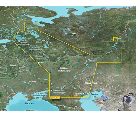
 BlueChart g2 - HRU001R - Russian Inland Waterways 2015.5 (17.00)
BlueChart g2 - HRU001R - Russian Inland Waterways 2015.5 (17.00)
Part Number: MicroSD/SD (010-C1048-20), Download (010-D0820-00)
See your vessels precise, on-chart position in relation to navaids, coastal features, anchorages, obstructions, waterways, restricted areas and more with this detailed marine mapping data.
- Shaded depth contours, coastlines, spot soundings, navaids, port plans, wrecks, obstructions, intertidal zones, restricted areas and IALA symbols.
- Seamless transitions between zoom levels and more continuity across chart boundaries.
- Standard 2-D direct overhead or 3-D over the bow map perspective for easy chart reading and orientation.
- Safety Shading* enables contour shading for all depth contours shallower than your defined safe depths.
- Fishing Charts* to scope out bottom contours and depth soundings with less visual clutter on the display.
- Plan and organize routes from your computer with HomePort (sold separately).
Coverage
This Cyrillic data card details main channel coverage of the major river systems and lakes of western Russia. Detailed coverage includes the Don R. from the Sea of Azov (Azovskoe More) to the Tsimlyanskoe Reservoir (Tsimlyansk Vodokhranilishche); the Volga-Don Canal (Volgo-Donskoy Kanal) to the Volga R. which is shown in its entirety; the Kama R. from Tyul'kino to the Volga R.; the Oka R. from Kaluga to its junction with the Moskva R; the Sheksna R. in its entirety; Lake Beloe (Beloye Ozero); the Volga-Baltic Canal (Volgo-Baltiyskiy Kanal); Lake Onega (Onezhskoe Ozero); the Svir R. to Lake Ladoga (Ladozhskoye Ozero); and the Neva R. to St. Petersburg (Sankt-Peterburg). Also included are the Volga-Baltic Waterway including the Rybinsk Reservoir (Rybinskoye Vodokhranilishche), the entire White Sea-Baltic Canal, Lakes Onega (Onezhskoe), Ladoga (Ladozhskoye), and Beloe (Beloye).
FID: 3840, PID: 1, RID: 17, VID: 2
Locked Image:
UnLocked Image:
 p33dro Reviewed by p33dro on . BlueChart g2 - HRU001R - Russian Inland Waterways 2015.5 (17.00) BlueChart g2 - HRU001R - Russian Inland Waterways 2015.5 (17.00) Part Number: MicroSD/SD (010-C1048-20), Download (010-D0820-00) See your vessels precise, on-chart position in relation to navaids, coastal features, anchorages, obstructions, waterways, restricted areas and more with this detailed marine mapping data. Shaded depth contours, coastlines, spot soundings, navaids, port plans, wrecks, obstructions, intertidal zones, restricted areas and IALA symbols. Seamless Rating: 5When nothing goes right, go left.
-
The Following 1 Users Say Thank You to p33dro For This Useful Post:
- [ Click To Expand ]
-
Bandos (13th April 2017)
-
26th March 2021, 06:40 PM #2

Re-uploaded this release
Enjoy.


 Register To Reply
Advertisements

Suggested Articles:

Similar Threads
-
BlueChart g2 - HEU060R - Germany Inland Waters 2015.5 [17.00]
By PiEtU in forum Garmin ArchivesReplies: 1Last Post: 25th March 2021, 04:15 PM -
BlueChart g2 - HEU062R - Russian Inland Waterways v17.50 [2016]
By PiEtU in forum Garmin ArchivesReplies: 2Last Post: 25th March 2021, 02:36 AM -
BlueChart g2 - HEU060R - Germany Inland Waters 2015.5 [17.00]
By PiEtU in forum Garmin MapsReplies: 0Last Post: 20th March 2016, 11:55 AM -
BlueChart g2 - HEU062R - Russian Inland Waterways v17.50 [2016]
By PiEtU in forum Garmin MapsReplies: 0Last Post: 26th February 2016, 11:38 PM -
BlueChart g2 - HRU001R - Russian Inland Waterways 2015.5 (17.00)
By p33dro in forum Garmin MapsReplies: 0Last Post: 25th March 2014, 05:24 PM


 Staff Online
City Navigator Europe NT 2025.10...
New map requires 14 GB......... with GE & the...